Supermarket nearby Klas Centar
Bosnia and Herzegovina
Supermarket nearby Klas Centar
Klas Centar
56, Paromlinska, 71000, Sarajevo, Sarajevska županija, BA Bosnia and Herzegovina
contacts phone
:
+387
Latitude:
43.8542681
, Longitude:
18.3756135
larger map & directions
read more
nearest Supermarket
527 m
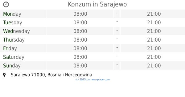
Konzum
Džemala Bijedića 10, Sarajevo
Supermarket
read more
536 m
Mercator
Džemala Bijedića 11, Sarajevo
Supermarket
read more
616 m
Amko
Azize Šaćirbegović 14, Sarajevo
Supermarket
read more
740 m
Konzum
Džemala Bijedića 123, Sarajevo
Supermarket
read more
870 m
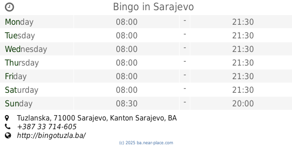
Bingo
Tuzlanska, Sarajevo
Supermarket
read more
871 m
Konzum
Gradačačka 56, Sarajevo
Supermarket
read more
879 m
Bingo
Aleja Lipa 55, Sarajevo
Supermarket
read more
884 m
Bingo Hipermarket
Gradačačka, Sarajevo
Supermarket
read more
917 m
Saray market 4
71000, Gradačačka 1, Sarajevo
Supermarket
read more
960 m
Amko
Trg heroja 25, Sarajevo
Supermarket
read more
1.145 km
Amko
Prijedorska 11a, Sarajevo
Supermarket
read more
1.316 km
Best BiH
Unnamed Road, Sarajevo 71000
Supermarket
read more
1.606 km
Amko komerc
71000, Grbavička 40, Sarajevo
Supermarket
read more
1.632 km
Klas
71000, Grbavička 52, Sarajevo
Supermarket
read more
1.676 km
Konzum
Grbavička 46, Sarajevo
Supermarket
read more
2.2 km
Amko
Trg solidarnosti, Sarajevo
Supermarket
read more
2.289 km
Penny Plus
Trg solidarnosti, Sarajevo
Supermarket
read more
2.301 km
Konzum
Smaila Šikala, Sarajevo
Supermarket
read more
2.447 km
Konzum
Smaila Šikala 26, Sarajevo
Supermarket
read more
2.472 km
Bingo
Ive Andrića 13, Sarajevo
Supermarket
read more
2.497 km
Swisslion Takovo Cash & Carry
Sarajevo
Supermarket
read more
2.607 km
B FAZA
71000, Nerkeza Smailagića, Sarajevo
Supermarket
read more
2.879 km
Konzum
Sarajevo
Supermarket
read more
2.923 km
Amko
Olimpijska 52, Sarajevo
Supermarket
read more
3.686 km
Konzum
Bulevar branilaca Dobrinje, Sarajevo
Supermarket
read more
📑
all categories
Accounting
Administrative area level 1
Administrative area level 2
Airport
Amusement park
Art gallery
Atm
Bakery
Bank
Bar
Beauty salon
Bicycle store
Book store
Bowling alley
Bus station
Cafe
Campground
Car dealer
Car rental
Car repair
Car wash
Casino
Cemetery
Church
City hall
Clothing store
Convenience store
Country
Courthouse
Dentist
Department store
Doctor
Electrician
Electronics store
Embassy
Establishment
Finance
Fire station
Florist
Food
Funeral home
Furniture store
Gas station
General contractor
Grocery or supermarket
Gym
Hair care
Hardware store
Health
Home goods store
Hospital
Insurance agency
Jewelry store
Laundry
Lawyer
Library
Light rail station
Liquor store
Local government office
Locality
Locksmith
Lodging
Meal delivery
Meal takeaway
Mosque
Movie rental
Movie theater
Moving company
Museum
Natural feature
Neighborhood
Night club
Park
Parking
Pet store
Pharmacy
Place of worship
Point of interest
Police
Post office
Premise
Real estate agency
Restaurant
Roofing contractor
Route
Rv park, camping
School
Shoe store
Shopping mall
Spa
Stadium
Storage
Store
Supermarket
Synagogue
Taxi stand
Train station
Transit station
Travel agency
University
Veterinary care
Zoo
administrative area level 3
sublocality level 1
↑