Supermarket nearby Bingo
Bosnia and Herzegovina
Supermarket nearby Bingo
Bingo
Trg državnosti, 88400, Konjic, Hercegovačko-neretvanski kanton, BA Bosnia and Herzegovina
contacts phone
:
+387 36 281-430
website:
www.bingotuzla.ba
Latitude:
43.6552571
, Longitude:
17.9622724
larger map & directions
read more
nearest Supermarket
172 m
Centralprom
Željeznička 2, Konjic
Supermarket
read more
302 m
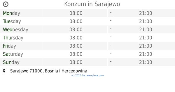
Konzum
Kolonija 8, Konjic
Supermarket
read more
711 m
Voćepromet
Zuke Džumhura, Konjic
Supermarket
read more
33.835 km
Konzum
Mala aleja 72, Ilidža
Supermarket
read more
34.026 km
Mercator
Butmirska cesta 14, Ilidža
Supermarket
read more
35.888 km
Konzum
Rudolfa Rude Tomića 3, Sarajevo
Supermarket
read more
36.234 km
Namex 10
Kneza Višeslava, Mostar
Supermarket
read more
36.336 km
Bingo
Dr. Silve Rizvanbegović
Supermarket
read more
36.427 km
Promex
a,, Aleja Bosne Srebrene 40, Sarajevo
Supermarket
read more
36.693 km
Bingo Dobrinja Pj32
Hamdije Kapidžića 8, Sarajevo
Supermarket
read more
36.794 km
Mar Tom
Kralja Tomislava, Mostar
Supermarket
read more
37.226 km
KETTI DOO SVIJET LJUBIMACA
Biskupa Cule bb, Mostar
Supermarket
read more
37.289 km
B FAZA
71000, Nerkeza Smailagića, Sarajevo
Supermarket
read more
37.554 km
Swisslion Takovo Cash & Carry
Sarajevo
Supermarket
read more
38.399 km
Konzum
Smaila Šikala, Sarajevo
Supermarket
read more
38.89 km
Amko
Prijedorska 11a, Sarajevo
Supermarket
read more
39.001 km
Isić Nova
Mostar
Supermarket
read more
39.11 km
Konzum
Gradačačka 56, Sarajevo
Supermarket
read more
40.091 km
Amko
Trg heroja 25, Sarajevo
Supermarket
read more
40.299 km
Bingo
Aleja Lipa 55, Sarajevo
Supermarket
read more
40.978 km
Amko komerc
71000, Grbavička 40, Sarajevo
Supermarket
read more
41.01 km
Konzum
Grbavička 46, Sarajevo
Supermarket
read more
42.076 km
Konzum
Sarajevo
Supermarket
read more
42.752 km
Amko
71000, Skenderija 25, Sarajevo
Supermarket
read more
61.936 km
Bingo
Bugojno
Supermarket
read more
📑
all categories
Accounting
Administrative area level 1
Administrative area level 2
Airport
Amusement park
Art gallery
Atm
Bakery
Bank
Bar
Beauty salon
Bicycle store
Book store
Bowling alley
Bus station
Cafe
Campground
Car dealer
Car rental
Car repair
Car wash
Casino
Cemetery
Church
City hall
Clothing store
Convenience store
Country
Courthouse
Dentist
Department store
Doctor
Electrician
Electronics store
Embassy
Establishment
Finance
Fire station
Florist
Food
Funeral home
Furniture store
Gas station
General contractor
Grocery or supermarket
Gym
Hair care
Hardware store
Health
Home goods store
Hospital
Insurance agency
Jewelry store
Laundry
Lawyer
Library
Light rail station
Liquor store
Local government office
Locality
Locksmith
Lodging
Meal delivery
Meal takeaway
Mosque
Movie rental
Movie theater
Moving company
Museum
Natural feature
Neighborhood
Night club
Park
Parking
Pet store
Pharmacy
Place of worship
Point of interest
Police
Post office
Premise
Real estate agency
Restaurant
Roofing contractor
Route
Rv park, camping
School
Shoe store
Shopping mall
Spa
Stadium
Storage
Store
Supermarket
Synagogue
Taxi stand
Train station
Transit station
Travel agency
University
Veterinary care
Zoo
administrative area level 3
sublocality level 1
↑