Bank nearby Sparkasse Bank
Bosnia and Herzegovina
Bank nearby Sparkasse Bank
Sparkasse Bank
2, Samira Ćatovića Kobre, Ilidža, Kanton Sarajevo, BA Bosnia and Herzegovina
contacts phone
:
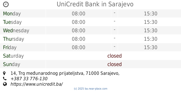
+387 33 764-925
website:
www.sparkasse.ba
Latitude:
43.8299083
, Longitude:
18.3039065
larger map & directions
read more
nearest Bank
109 m
ProCredit Bank
Ibrahima Ljubovića 20, Sarajevo
Bank
read more
143 m
Raiffeisen BANK
Ilidža, Rustempasina bb
Bank
read more
198 m
ZiraatBank
Rustem-pašina 1, Ilidža
Bank
read more
207 m
NLB Banka
Mala aleja 1, Ilidža
Bank
read more
224 m
UniCredit Bank
Mala aleja 10, Ilidža
Bank
read more
228 m
Intesa Sanpaolo Banka
Mala aleja, Ilidža
Bank
read more
230 m
Uniqa Osiguranje
Ilidža
Bank
read more
351 m
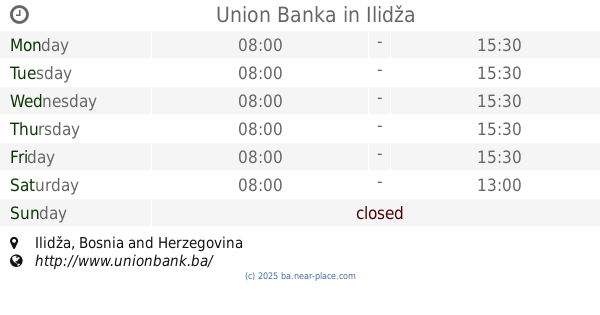
Union Banka
Ilidža
Bank
read more
383 m
Hypo Alpe-Adria-Bank
Rustem-pašina 1, Ilidža
Bank
read more
411 m
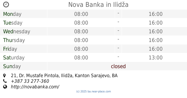
Nova Banka
Dr. Mustafe Pintola 21, Ilidža
Bank
read more
420 m
Vakufska banka
Dr. Mustafe Pintola 25, Ilidža
Bank
read more
501 m
Raiffeisen BANK
Dr. Mustafe Pintola bb, Ilidža
Bank
read more
504 m
Bosna Bank International
Ilidža
Bank
read more
506 m
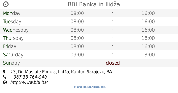
BBI Banka
Dr. Mustafe Pintola 23, Ilidža
Bank
read more
595 m
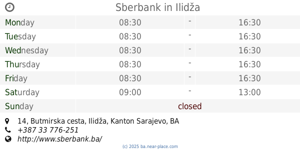
Sberbank
Butmirska cesta 14, Ilidža
Bank
read more
2.054 km
UniCredit bankomat
Stup, Sarajevo
Bank
read more
3.236 km
Raiffeisen BANK
Bulevar branilaca Dobrinje & Dobrinjske bolnice, Sarajevo
Bank
read more
3.466 km
IK Banka
Ante Babića, Sarajevo
Bank
read more
3.475 km
UniCredit Bank
Trg međunarodnog prijateljstva 14, Sarajevo
Bank
read more
3.575 km
UniCredit Bank
Mustafe Kamerića 5, Sarajevo
Bank
read more
3.721 km
Intesa Sanpaolo Banka
Nurije Pozderca 6, Sarajevo
Bank
read more
4.813 km
Комерцијална банка
71123, Spasovdanska 22, Lukavica
Bank
read more
4.95 km
МФ банка
Sime Milutinovića Sarajlije 2, Lukavica
Bank
read more
5.069 km
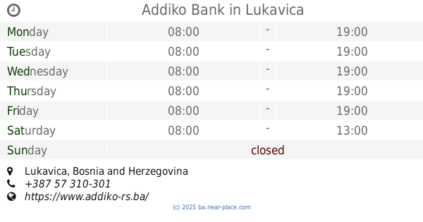
Addiko Bank
Lukavica
Bank
read more
5.173 km
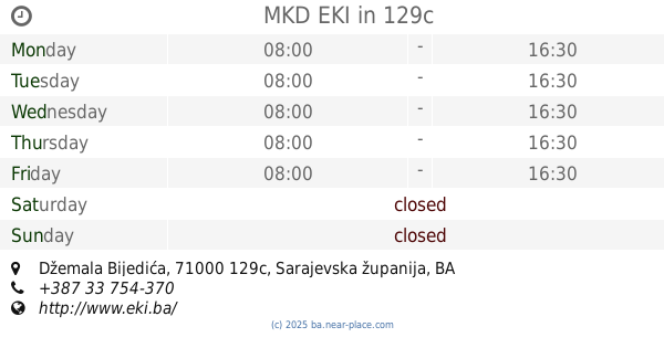
MKD EKI
Džemala Bijedića, 129c
Bank
read more
📑
all categories
Accounting
Administrative area level 1
Administrative area level 2
Airport
Amusement park
Art gallery
Atm
Bakery
Bank
Bar
Beauty salon
Bicycle store
Book store
Bowling alley
Bus station
Cafe
Campground
Car dealer
Car rental
Car repair
Car wash
Casino
Cemetery
Church
City hall
Clothing store
Convenience store
Country
Courthouse
Dentist
Department store
Doctor
Electrician
Electronics store
Embassy
Establishment
Finance
Fire station
Florist
Food
Funeral home
Furniture store
Gas station
General contractor
Grocery or supermarket
Gym
Hair care
Hardware store
Health
Home goods store
Hospital
Insurance agency
Jewelry store
Laundry
Lawyer
Library
Light rail station
Liquor store
Local government office
Locality
Locksmith
Lodging
Meal delivery
Meal takeaway
Mosque
Movie rental
Movie theater
Moving company
Museum
Natural feature
Neighborhood
Night club
Park
Parking
Pet store
Pharmacy
Place of worship
Point of interest
Police
Post office
Premise
Real estate agency
Restaurant
Roofing contractor
Route
Rv park, camping
School
Shoe store
Shopping mall
Spa
Stadium
Storage
Store
Supermarket
Synagogue
Taxi stand
Train station
Transit station
Travel agency
University
Veterinary care
Zoo
administrative area level 3
sublocality level 1
↑