Store nearby Palada
Bosnia and Herzegovina
Store nearby Palada
Palada
Kulina Bana 8, Bijeljina 76300, Bosnia and Herzegovina
contacts phone
:
+387
website:
www.facebook.com
Latitude:
44.755703
, Longitude:
19.205281
larger map & directions
read more
nearest Store
470 m
Ribarnica Darko-L
Filipa Višnjića 76, Bijeljina
Store
read more
494 m
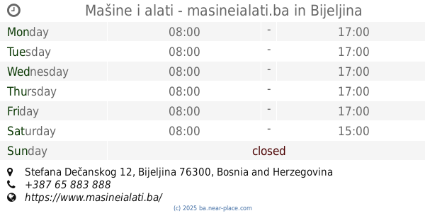
Mašine i alati - masineialati.ba
Stefana Dečanskog 12, Bijeljina
Store
read more
550 m
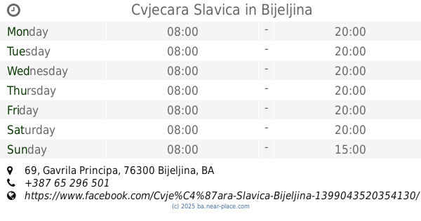
Cvjecara Slavica
Gavrila Principa 69, Bijeljina
Store
read more
551 m
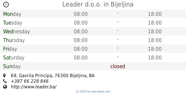
Leader d.o.o.
Gavrila Principa 69, Bijeljina
Store
read more
591 m
Ešpek d.o.o.
90, Filipa Višnjića
Store
read more
777 m
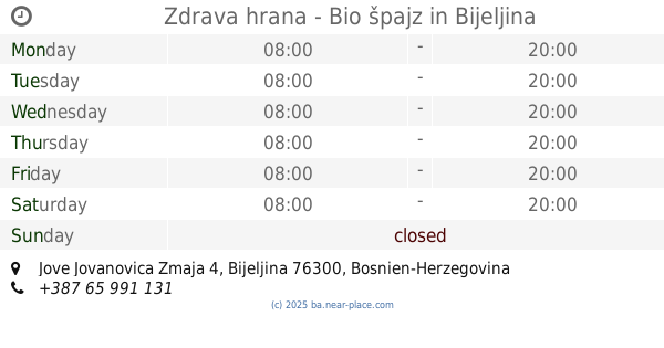
Zdrava hrana - Bio špajz
Jove Jovanovica Zmaja 4, Bijeljina
Store
read more
790 m
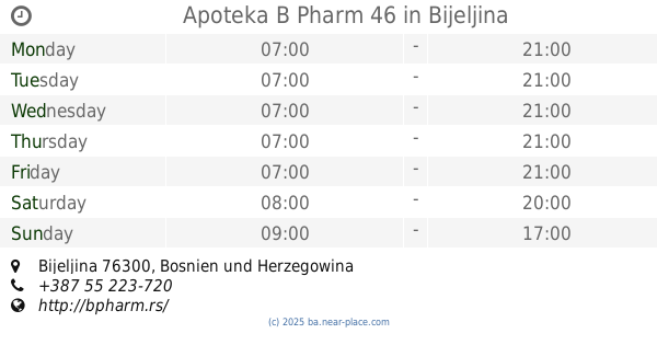
Apoteka B Pharm 46
Bijeljina
Store
read more
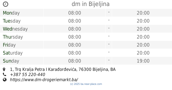
811 m
dm
Trg Kralja Petra I Karađorđevića 1, Bijeljina
Store
read more
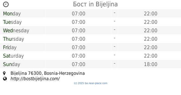
1.193 km
Бост
Bijeljina
Store
read more
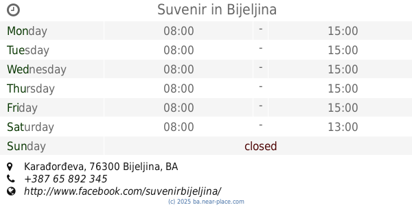
1.274 km
Suvenir
Karađorđeva
Store
read more
1.274 km
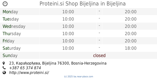
Proteini.si Shop Bijeljina
23, Карађорђева
Store
read more
1.549 km
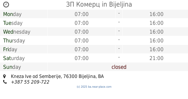
ЗП Комерц
Kneza Ive od Semberije, Bijeljina
Store
read more
1.571 km
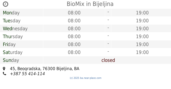
BioMix
Beogradska 45, Bijeljina
Store
read more
3.943 km
Izgradnja
M14.1, Patkovača
Store
read more
4.494 km
Auto sajla Gordić
Ćipirovine
Store
read more
4.735 km
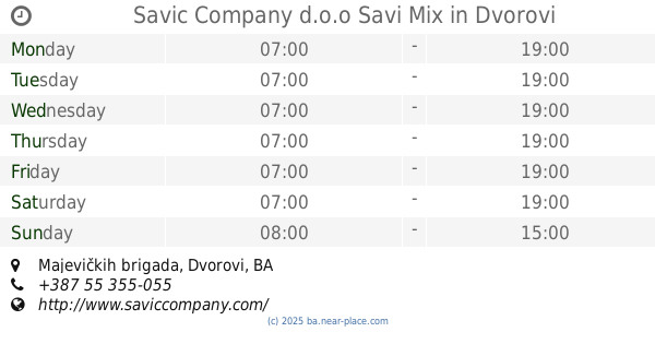
Savic Company d.o.o Savi Mix
Majevičkih brigada, Dvorovi
Store
read more
5.179 km
Vitamedic d.o.o.
Dvorovi
Store
read more
7.482 km
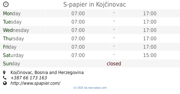
S-papier
Kojčinovac
Store
read more
10.774 km
Bingo
Karađođeva, Bijeljinska 201, Janja
Store
read more
34.858 km
INTERSPORT BRČKO
Reisa Džemaludina Čauševića bb, Brčko
Store
read more
49.15 km
Badžo
Poduzetnička zona, Orašje
Store
read more
49.52 km
Widex Slušni Centar Tuzla
Obala Zmaja od Bosne & Bosne Srebrene, Tuzla
Store
read more
55.527 km
Didaco
Alije Izetbegovića 10, Živinice Grad
Store
read more
55.579 km
DUHAN 7
75270, Druga ulica 22, Živinice Grad
Store
read more
55.711 km
Izbor trgovine
Pašage Gogića 1, Živinice Grad
Store
read more
📑
all categories
Accounting
Administrative area level 1
Administrative area level 2
Airport
Amusement park
Art gallery
Atm
Bakery
Bank
Bar
Beauty salon
Bicycle store
Book store
Bowling alley
Bus station
Cafe
Campground
Car dealer
Car rental
Car repair
Car wash
Casino
Cemetery
Church
City hall
Clothing store
Convenience store
Country
Courthouse
Dentist
Department store
Doctor
Electrician
Electronics store
Embassy
Establishment
Finance
Fire station
Florist
Food
Funeral home
Furniture store
Gas station
General contractor
Grocery or supermarket
Gym
Hair care
Hardware store
Health
Home goods store
Hospital
Insurance agency
Jewelry store
Laundry
Lawyer
Library
Light rail station
Liquor store
Local government office
Locality
Locksmith
Lodging
Meal delivery
Meal takeaway
Mosque
Movie rental
Movie theater
Moving company
Museum
Natural feature
Neighborhood
Night club
Park
Parking
Pet store
Pharmacy
Place of worship
Point of interest
Police
Post office
Premise
Real estate agency
Restaurant
Roofing contractor
Route
Rv park, camping
School
Shoe store
Shopping mall
Spa
Stadium
Storage
Store
Supermarket
Synagogue
Taxi stand
Train station
Transit station
Travel agency
University
Veterinary care
Zoo
administrative area level 3
sublocality level 1
↑