Store nearby Lutrija Bosne i Hercegovine
Bosnia and Herzegovina
Store nearby Lutrija Bosne i Hercegovine
Lutrija Bosne i Hercegovine
16, Univerzitetska, 75000, Tuzla, Tuzlanski kanton, BA Bosnia and Herzegovina
contacts phone
:
+387 35 264-760
website:
www.lutrijabih.ba
Latitude:
44.5387402
, Longitude:
18.6644585
larger map & directions
read more
nearest Store
214 m
Proteini.si Shop
Bosne Srebrene bb
Store
read more
382 m
Biljna apoteka La Vita
Bosne Srebrene 75, Tuzla
Store
read more
420 m
Widex Slušni Centar Tuzla
Obala Zmaja od Bosne & Bosne Srebrene, Tuzla
Store
read more
484 m
TR Saten
Džafer mahala 35, Tuzla
Store
read more
487 m
Saten Pozamanterija
Džafer mahala 35, Tuzla
Store
read more
507 m
Krojački salon Karmen
Dzafer Mahala broj 35, Tuzla
Store
read more
555 m
Farmacolux
Džafer mahala 17, Tuzla
Store
read more
709 m
Lira
Tabašnice, Tuzla
Store
read more
734 m
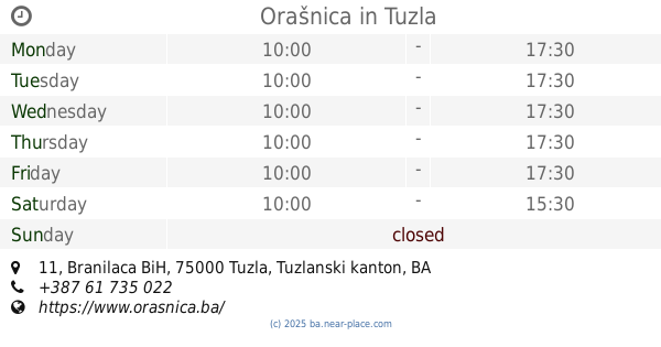
Orašnica
Tabašnice 23, Tuzla
Store
read more
737 m
Rikošet
Franjevačka 17, Tuzla
Store
read more
774 m
Kožeks
Franjevačka 2, Tuzla
Store
read more
814 m
Parfimerija NECA TUZLA
Malkočeva 5, Tuzla
Store
read more
826 m
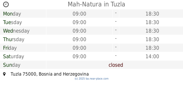
Mah-Natura
Tuzla
Store
read more
3.54 km
Orašnica
Branilaca BiH 11, Tuzla
Store
read more
3.547 km
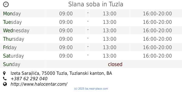
Slana soba
Izeta Sarajlića, Tuzla
Store
read more
5.784 km
Zeka Komerc
Bukinje
Store
read more
6.478 km
Mobile plus
Šićki Brod
Store
read more
9.374 km
DUHAN 7
75270, Druga ulica 22, Živinice Grad
Store
read more
9.865 km
Didaco
Alije Izetbegovića 10, Živinice Grad
Store
read more
10.258 km
MOBIH Mobi Shop
Pašage Gogića bb, Živinice Grad
Store
read more
10.312 km
Izbor trgovine
Pašage Gogića 1, Živinice Grad
Store
read more
10.566 km
ZH Zola
Prva ulica 11, Živinice Grad
Store
read more
10.669 km
Tokan
Kulina bana, Lukavac
Store
read more
10.687 km
Meki Commerce
Kulina bana, Lukavac
Store
read more
10.716 km
Izbor trgovine
Lukavac
Store
read more
📑
all categories
Accounting
Administrative area level 1
Administrative area level 2
Airport
Amusement park
Art gallery
Atm
Bakery
Bank
Bar
Beauty salon
Bicycle store
Book store
Bowling alley
Bus station
Cafe
Campground
Car dealer
Car rental
Car repair
Car wash
Casino
Cemetery
Church
City hall
Clothing store
Convenience store
Country
Courthouse
Dentist
Department store
Doctor
Electrician
Electronics store
Embassy
Establishment
Finance
Fire station
Florist
Food
Funeral home
Furniture store
Gas station
General contractor
Grocery or supermarket
Gym
Hair care
Hardware store
Health
Home goods store
Hospital
Insurance agency
Jewelry store
Laundry
Lawyer
Library
Light rail station
Liquor store
Local government office
Locality
Locksmith
Lodging
Meal delivery
Meal takeaway
Mosque
Movie rental
Movie theater
Moving company
Museum
Natural feature
Neighborhood
Night club
Park
Parking
Pet store
Pharmacy
Place of worship
Point of interest
Police
Post office
Premise
Real estate agency
Restaurant
Roofing contractor
Route
Rv park, camping
School
Shoe store
Shopping mall
Spa
Stadium
Storage
Store
Supermarket
Synagogue
Taxi stand
Train station
Transit station
Travel agency
University
Veterinary care
Zoo
administrative area level 3
sublocality level 1
↑