Restaurant nearby Ribnjak
Bosnia and Herzegovina
Restaurant nearby Ribnjak
Ribnjak
bb, Klopići, 75270, Priluk, Tuzlanski kanton, BA Bosnia and Herzegovina
contacts phone
:
+387
Latitude:
44.4586404
, Longitude:
18.5178128
larger map & directions
read more
nearest Restaurant
1.449 km
HD Trumić
Priluk
Restaurant
read more
3.344 km
Kod Hašima
R455a, Poljice
Restaurant
read more
3.51 km
M&M
Šerići
Restaurant
read more
8.361 km
Doner Kebab
75300, Lukavac
Restaurant
read more
8.519 km
Ognjište
Septembarska, Lukavac
Restaurant
read more
8.584 km
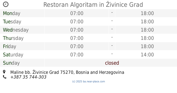
Restoran Algoritam
Maline bb, Živinice Grad
Restaurant
read more
8.783 km
Локум
Spreča
Restaurant
read more
9.432 km
Svadbeni salon HD Živinice
Živinice Grad
Restaurant
read more
10.575 km
Bosna
Alije Izetbegovića 23, Živinice Grad
Restaurant
read more
10.613 km
Sezam
Živinice Grad
Restaurant
read more
10.671 km
Jasmina
25. novembar, Živinice Grad
Restaurant
read more
10.784 km
Pituljica
Druga ulica, Živinice Grad
Restaurant
read more
13.904 km
Grand Club Tuzla
75000, Branislava Nušića 43, Tuzla
Restaurant
read more
14.92 km
Boom Burger
Franjevačka 3, Tuzla
Restaurant
read more
14.98 km
Fresh
Džafer mahala 57, Tuzla
Restaurant
read more
15.05 km
Konoba Lovac
Fra Grge Martića 34, Tuzla
Restaurant
read more
15.057 km
Pazar
Fra Grge Martića 32, Tuzla
Restaurant
read more
15.097 km
Coffee Pizzeria Lav
Slatina, Tuzla
Restaurant
read more
15.197 km
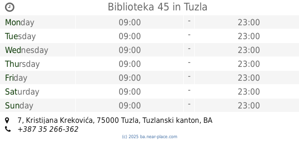
Biblioteka 45
Kristijana Krekovića 7, Tuzla
Restaurant
read more
15.489 km
Mozaik
Bulevar 2. korpusa Armije Republike Bosne i Hercegovine, Tuzla
Restaurant
read more
15.659 km
Hot Spot Fast Food
Dr. Tihomila Markovića, Tuzla
Restaurant
read more
15.872 km
Panorama
Panorama 8, Tuzla
Restaurant
read more
16.216 km
Aščinica Bujrum
75000, Sarajevska 30, Tuzla
Restaurant
read more
16.235 km
Salso
Aleja Alije Izetbegovića, Tuzla
Restaurant
read more
16.334 km
Saranda
Maršala Tita 88, Tuzla
Restaurant
read more
📑
all categories
Accounting
Administrative area level 1
Administrative area level 2
Airport
Amusement park
Art gallery
Atm
Bakery
Bank
Bar
Beauty salon
Bicycle store
Book store
Bowling alley
Bus station
Cafe
Campground
Car dealer
Car rental
Car repair
Car wash
Casino
Cemetery
Church
City hall
Clothing store
Convenience store
Country
Courthouse
Dentist
Department store
Doctor
Electrician
Electronics store
Embassy
Establishment
Finance
Fire station
Florist
Food
Funeral home
Furniture store
Gas station
General contractor
Grocery or supermarket
Gym
Hair care
Hardware store
Health
Home goods store
Hospital
Insurance agency
Jewelry store
Laundry
Lawyer
Library
Light rail station
Liquor store
Local government office
Locality
Locksmith
Lodging
Meal delivery
Meal takeaway
Mosque
Movie rental
Movie theater
Moving company
Museum
Natural feature
Neighborhood
Night club
Park
Parking
Pet store
Pharmacy
Place of worship
Point of interest
Police
Post office
Premise
Real estate agency
Restaurant
Roofing contractor
Route
Rv park, camping
School
Shoe store
Shopping mall
Spa
Stadium
Storage
Store
Supermarket
Synagogue
Taxi stand
Train station
Transit station
Travel agency
University
Veterinary care
Zoo
administrative area level 3
sublocality level 1
↑