Restaurant nearby Restoran Ilić
Bosnia and Herzegovina
Restaurant nearby Restoran Ilić
Restoran Ilić
1. maja, Derventa, BA Bosnia and Herzegovina
contacts phone
:
+387 53 331-094
Latitude:
44.9808915
, Longitude:
17.9186791
larger map & directions
read more
nearest Restaurant
830 m
Restoran TRANZIT
Derventa
Restaurant
read more
858 m
Buregdzinica Stara rampa
Kralja Petra I BB, Derventa
Restaurant
read more
1.02 km
Pekara Kljajić Kosijer
Trg Pravoslavlja 12, Derventa
Restaurant
read more
1.03 km
Caffe Restoran KORZO
Trg Pravoslavlja 12, Derventa
Restaurant
read more
1.033 km
Gradska Kafana Derventa
Srpske vojske, Derventa
Restaurant
read more
1.06 km
Del Capo
Srpske vojske, Derventa
Restaurant
read more
1.133 km
Caribic
Cara Lazara 6, Derventa
Restaurant
read more
1.307 km
caffe I cevabdžinica BOOMERANG
Trive Vujića, Derventa
Restaurant
read more
1.703 km
KeteringMarco PoloDerventa
M16.1, Derventa
Restaurant
read more
2.024 km
Lovac
Derventa
Restaurant
read more
4.659 km
Koktel
lug bb
Restaurant
read more
4.722 km
Eden
Bosanski Lužani bb, Derventa
Restaurant
read more
7.342 km
Odmaralište
Derventa
Restaurant
read more
7.945 km
Stari Hrast
Derventa
Restaurant
read more
30.452 km
Руданка Добој
74000, Carice Milice, Doboj
Restaurant
read more
30.823 km
City
Cara Dušana 37, Doboj
Restaurant
read more
35.756 km
Etnoavlija
Klokotnica
Restaurant
read more
35.889 km
Restoran SUNCE
Jelah
Restaurant
read more
36.787 km
Marshall Pub Staropramen
Braće Kotorić, Jelah
Restaurant
read more
40.121 km
Ukus
Put Izudina Alićehajića, Tešanj
Restaurant
read more
41.469 km
Caffe Bar-Disco Klub Vanila
Braće Pobrić, Tešanj
Restaurant
read more
48.679 km
PJ Restorant
Mahovljani
Restaurant
read more
48.807 km
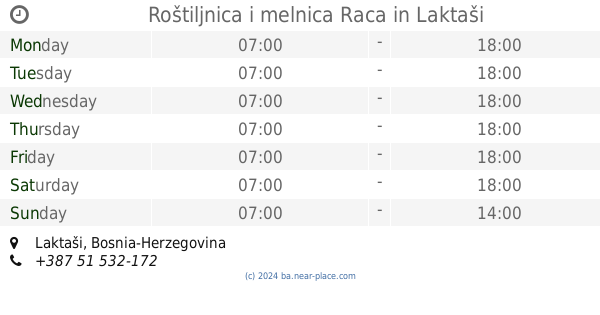
Roštiljnica i melnica Raca
Laktaši
Restaurant
read more
55.328 km
Restoran Laguna
Trg Prvog K. P. O., Čelinac
Restaurant
read more
69.598 km
Doner Kebab
75300, Lukavac
Restaurant
read more
📑
all categories
Accounting
Administrative area level 1
Administrative area level 2
Airport
Amusement park
Art gallery
Atm
Bakery
Bank
Bar
Beauty salon
Bicycle store
Book store
Bowling alley
Bus station
Cafe
Campground
Car dealer
Car rental
Car repair
Car wash
Casino
Cemetery
Church
City hall
Clothing store
Convenience store
Country
Courthouse
Dentist
Department store
Doctor
Electrician
Electronics store
Embassy
Establishment
Finance
Fire station
Florist
Food
Funeral home
Furniture store
Gas station
General contractor
Grocery or supermarket
Gym
Hair care
Hardware store
Health
Home goods store
Hospital
Insurance agency
Jewelry store
Laundry
Lawyer
Library
Light rail station
Liquor store
Local government office
Locality
Locksmith
Lodging
Meal delivery
Meal takeaway
Mosque
Movie rental
Movie theater
Moving company
Museum
Natural feature
Neighborhood
Night club
Park
Parking
Pet store
Pharmacy
Place of worship
Point of interest
Police
Post office
Premise
Real estate agency
Restaurant
Roofing contractor
Route
Rv park, camping
School
Shoe store
Shopping mall
Spa
Stadium
Storage
Store
Supermarket
Synagogue
Taxi stand
Train station
Transit station
Travel agency
University
Veterinary care
Zoo
administrative area level 3
sublocality level 1
↑