Restaurant nearby Fast Food Beni
Bosnia and Herzegovina
Restaurant nearby Fast Food Beni
Fast Food Beni
Bilmišće, 72000, Zenica, Zeničko-dobojski kanton, BA Bosnia and Herzegovina
contacts phone
:
+387 62 747 014
Latitude:
44.1931895
, Longitude:
17.9213962
larger map & directions
read more
nearest Restaurant
106 m
D-S MONT pvc stolarija
Bilmišće, Zenica
Restaurant
read more
327 m
Restoran Ušće
Ušće 6, Zenica
Restaurant
read more
381 m
Fast Food EKIN
Zenica
Restaurant
read more
398 m
Ada
Ušće, Zenica
Restaurant
read more
473 m
Fast Food Big Beni
Zenica, Sejmenska 17
Restaurant
read more
480 m
Buregdžinica Palma
72000, Londža, Zenica
Restaurant
read more
608 m
Fast Food Jambo I
Londža bb, Zenica
Restaurant
read more
740 m
Cacadu
Prve zeničke brigade 3A, Zenica
Restaurant
read more
835 m
Fast Food Sarajlic
Babina rijeka
Restaurant
read more
869 m
Buregdžinica SAM
Talića brdo 13, Zenica
Restaurant
read more
925 m
Dolce Vita
Armije Republike Bosne i Hercegovine 8, Zenica
Restaurant
read more
964 m
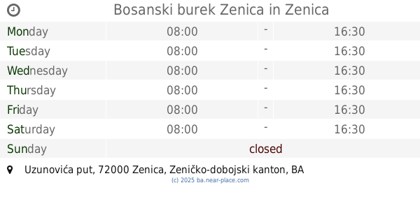
Bosanski burek Zenica
Uzunovića put, Zenica
Restaurant
read more
973 m
Urban Grill (2)
Potok, Zenica
Restaurant
read more
1.046 km
Miris dunja
Sarajevska 53, Zenica
Restaurant
read more
1.25 km
Sweet
Zenica
Restaurant
read more
1.371 km
Kod Seje
Maršala Tita, Zenica
Restaurant
read more
1.428 km
Kaktus 5
Maršala Tita, Zenica
Restaurant
read more
1.493 km
GRICKO fast Food
Crkvice 56, Zenica
Restaurant
read more
1.621 km
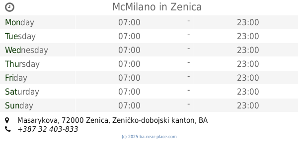
McMilano
Masarykova, Zenica
Restaurant
read more
1.662 km
Good food
Školska 2, Zenica
Restaurant
read more
1.885 km
Pizzeria Machiato
Zenica
Restaurant
read more
1.9 km
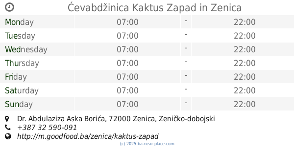
Ćevabdžinica Kaktus Zapad
Dr. Abdulaziza Aska Borića, Zenica
Restaurant
read more
2.09 km
Essen 2
Kranjčevićeva 9, Zenica
Restaurant
read more
2.123 km
Fast Food ZS
Bulevar Kralja Tvrtka I, Zenica
Restaurant
read more
2.2 km
Fast Food Baltazar
Adolfa Goldbergera 13, Zenica
Restaurant
read more
📑
all categories
Accounting
Administrative area level 1
Administrative area level 2
Airport
Amusement park
Art gallery
Atm
Bakery
Bank
Bar
Beauty salon
Bicycle store
Book store
Bowling alley
Bus station
Cafe
Campground
Car dealer
Car rental
Car repair
Car wash
Casino
Cemetery
Church
City hall
Clothing store
Convenience store
Country
Courthouse
Dentist
Department store
Doctor
Electrician
Electronics store
Embassy
Establishment
Finance
Fire station
Florist
Food
Funeral home
Furniture store
Gas station
General contractor
Grocery or supermarket
Gym
Hair care
Hardware store
Health
Home goods store
Hospital
Insurance agency
Jewelry store
Laundry
Lawyer
Library
Light rail station
Liquor store
Local government office
Locality
Locksmith
Lodging
Meal delivery
Meal takeaway
Mosque
Movie rental
Movie theater
Moving company
Museum
Natural feature
Neighborhood
Night club
Park
Parking
Pet store
Pharmacy
Place of worship
Point of interest
Police
Post office
Premise
Real estate agency
Restaurant
Roofing contractor
Route
Rv park, camping
School
Shoe store
Shopping mall
Spa
Stadium
Storage
Store
Supermarket
Synagogue
Taxi stand
Train station
Transit station
Travel agency
University
Veterinary care
Zoo
administrative area level 3
sublocality level 1
↑