Restaurant nearby Buregdžinica&Fastfood Centar
Bosnia and Herzegovina
Restaurant nearby Buregdžinica&Fastfood Centar
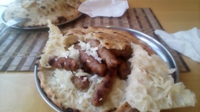
Buregdžinica&Fastfood Centar
6, Patriotske lige, 71000, Sarajevo, Kanton Sarajevo, BA Bosnia and Herzegovina
contacts phone
:
+387 33 223-999
Latitude:
43.8654508
, Longitude:
18.4127348
larger map & directions
read more
nearest Restaurant
121 m
Maksumić komerc
Patriotske lige, Sarajevo
Restaurant
read more
247 m
Pizzeria Fratelli
Ciglane, Sarajevo
Restaurant
read more
274 m
Lux
Merhemića trg, Sarajevo
Restaurant
read more
275 m
TEPA Salad bar
bb, Merhemića trg, Sarajevo
Restaurant
read more
291 m
ZMBT
Sarajevo
Restaurant
read more
324 m
KarKin
Čekaluša 64A, Sarajevo
Restaurant
read more
331 m
Avlija
Avde Sumbula 2, Sarajevo
Restaurant
read more
393 m
Tim
Avde Hume, Sarajevo
Restaurant
read more
776 m
Fast Food El Pollo
sejh mehmedova br1
Restaurant
read more
787 m
Burekdzinica Bjelave
Bjelave, Sarajevo
Restaurant
read more
863 m
Pivnica Sarajevo
Maršala Tita 7, Sarajevo
Restaurant
read more
873 m
DA VINCENZO
u. 45, Himze Polovine, Sarajevo
Restaurant
read more
895 m
Manolo
Maršala Tita 23, Sarajevo
Restaurant
read more
935 m
Kobaja
Maršala Tita 48, Sarajevo
Restaurant
read more
982 m
Fast Food Foody
Šenoina 8, Sarajevo
Restaurant
read more
1.004 km
Ćevabdžinica i buregdžinica Bagrem
Kranjčevićeva, Sarajevo
Restaurant
read more
1.006 km
Surf 'n' Fries
Kulovića 4, Sarajevo
Restaurant
read more
1.014 km
Nostra Cucina
Maršala Tita 54, Sarajevo
Restaurant
read more
1.041 km
Proba 1
71000, Kralja Tvrtka 5, Sarajevo
Restaurant
read more
1.062 km
Caffe restoran Libra
Kranjčevićeva 19, Sarajevo
Restaurant
read more
1.105 km
Pizza U2 Chicken
71000, Branilaca Sarajeva 23, Sarajevo
Restaurant
read more
1.114 km
Klopa
Ferhadija 5, Sarajevo
Restaurant
read more
1.115 km
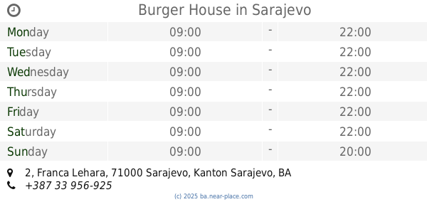
Burger House
2, Franca Lehara 2, Sarajevo
Restaurant
read more
1.147 km
Ago
Mula Mustafe Bašeskije 17, Sarajevo
Restaurant
read more
1.166 km
Boss Burger
Stakleni grad, Ferhadija, Sarajevo
Restaurant
read more
📑
all categories
Accounting
Administrative area level 1
Administrative area level 2
Airport
Amusement park
Art gallery
Atm
Bakery
Bank
Bar
Beauty salon
Bicycle store
Book store
Bowling alley
Bus station
Cafe
Campground
Car dealer
Car rental
Car repair
Car wash
Casino
Cemetery
Church
City hall
Clothing store
Convenience store
Country
Courthouse
Dentist
Department store
Doctor
Electrician
Electronics store
Embassy
Establishment
Finance
Fire station
Florist
Food
Funeral home
Furniture store
Gas station
General contractor
Grocery or supermarket
Gym
Hair care
Hardware store
Health
Home goods store
Hospital
Insurance agency
Jewelry store
Laundry
Lawyer
Library
Light rail station
Liquor store
Local government office
Locality
Locksmith
Lodging
Meal delivery
Meal takeaway
Mosque
Movie rental
Movie theater
Moving company
Museum
Natural feature
Neighborhood
Night club
Park
Parking
Pet store
Pharmacy
Place of worship
Point of interest
Police
Post office
Premise
Real estate agency
Restaurant
Roofing contractor
Route
Rv park, camping
School
Shoe store
Shopping mall
Spa
Stadium
Storage
Store
Supermarket
Synagogue
Taxi stand
Train station
Transit station
Travel agency
University
Veterinary care
Zoo
administrative area level 3
sublocality level 1
↑