Pharmacy nearby Poljoprivredna Apoteka
Bosnia and Herzegovina
Pharmacy nearby Poljoprivredna Apoteka
Poljoprivredna Apoteka
Devetak, Bosnia and Herzegovina
contacts phone
:
+387
Latitude:
44.5507074
, Longitude:
18.4710337
larger map & directions
read more
nearest Pharmacy
2.093 km
ADONIS apoteka
Devetak bb
Pharmacy
read more
4.817 km
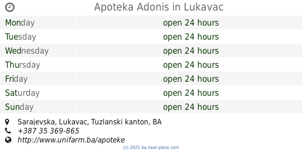
Apoteka Adonis
bb, Sarajevska, Lukavac
Pharmacy
read more
5.339 km
Altea
75300, Lukavac
Pharmacy
read more
7.84 km
Apoteka ''OS-Pharm''
26. avgusta, Mramor
Pharmacy
read more
7.88 km
Apotekarski depo Mramor
26. avgusta bb, Mramor Novi
Pharmacy
read more
9.437 km
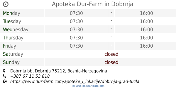
Apoteka Dur-Farm
Dobrnja bb, Dobrnja
Pharmacy
read more
10.253 km
Apoteka
Priluk
Pharmacy
read more
10.253 km
MEDICA-Priluk
Priluk
Pharmacy
read more
10.296 km
Eurofarm Edal
Kiseljak
Pharmacy
read more
11.584 km
Medex Pharm
Šerići
Pharmacy
read more
12.596 km
Mediflor
R455a, Bučik
Pharmacy
read more
13.215 km
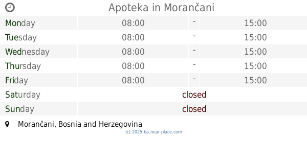
Apoteka
Morančani
Pharmacy
read more
13.542 km
Apoteka Đulović
Suha
Pharmacy
read more
15.008 km
Mediflor Apoteka
Šehidska bb, Pasci Donji
Pharmacy
read more
15.386 km
Mediflor
16, Univerzitetska
Pharmacy
read more
15.688 km
Apoteka Adonis
Albina i Franje Herljevića 6, Tuzla
Pharmacy
read more
15.69 km
Ibn Sina
Albina Hreljevića 4, Tuzla
Pharmacy
read more
17.258 km
Farmatex
Prva ulica 218, Živinice Grad
Pharmacy
read more
17.608 km
Bio Vita
B6, Tuzla
Pharmacy
read more
17.933 km
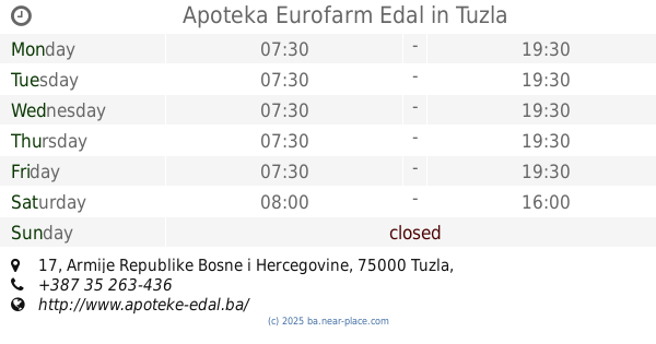
Apoteka Eurofarm Edal
15. maja, Tuzla
Pharmacy
read more
17.958 km
Apoteka Eurofarm Edal
Armije Republike Bosne i Hercegovine 17, Tuzla
Pharmacy
read more
18.356 km
Ibn Sina
Alije Izetbegovića 10, Živinice Grad
Pharmacy
read more
18.404 km
Đulović
Alije Izetbegovića 4, Živinice Grad
Pharmacy
read more
18.897 km
Apoteka Durić
Branilaca BiH 11, Tuzla
Pharmacy
read more
21.47 km
OS-PHARM
Dubrave Gornje
Pharmacy
read more
📑
all categories
Accounting
Administrative area level 1
Administrative area level 2
Airport
Amusement park
Art gallery
Atm
Bakery
Bank
Bar
Beauty salon
Bicycle store
Book store
Bowling alley
Bus station
Cafe
Campground
Car dealer
Car rental
Car repair
Car wash
Casino
Cemetery
Church
City hall
Clothing store
Convenience store
Country
Courthouse
Dentist
Department store
Doctor
Electrician
Electronics store
Embassy
Establishment
Finance
Fire station
Florist
Food
Funeral home
Furniture store
Gas station
General contractor
Grocery or supermarket
Gym
Hair care
Hardware store
Health
Home goods store
Hospital
Insurance agency
Jewelry store
Laundry
Lawyer
Library
Light rail station
Liquor store
Local government office
Locality
Locksmith
Lodging
Meal delivery
Meal takeaway
Mosque
Movie rental
Movie theater
Moving company
Museum
Natural feature
Neighborhood
Night club
Park
Parking
Pet store
Pharmacy
Place of worship
Point of interest
Police
Post office
Premise
Real estate agency
Restaurant
Roofing contractor
Route
Rv park, camping
School
Shoe store
Shopping mall
Spa
Stadium
Storage
Store
Supermarket
Synagogue
Taxi stand
Train station
Transit station
Travel agency
University
Veterinary care
Zoo
administrative area level 3
sublocality level 1
↑