Pharmacy nearby Moja Apoteka
Bosnia and Herzegovina
Pharmacy nearby Moja Apoteka
Moja Apoteka
Distrikt Brčko, Bosnien und Herzegowina
contacts phone
:
+387 49 490-250
website:
m.facebook.com
Latitude:
44.8770752
, Longitude:
18.7983363
larger map & directions
read more
nearest Pharmacy
53 m
Apoteka
Brčko
Pharmacy
read more
176 m
Ibn Sina
Reisa Džemaludina Čauševića 51a, Brčko
Pharmacy
read more
185 m
Apoteka Onion
Brčko
Pharmacy
read more
363 m
Apoteka Herbafarm
Reisa Džemaludina Čauševića 21, Brčko
Pharmacy
read more
796 m
Apoteka Herbafarm
Banjalučka 15, Dejtonska 15, Brčko
Pharmacy
read more
920 m
Apoteka 1, ZU Pajić medikal
KONAČKO BRDO 2, Brčko
Pharmacy
read more
967 m
Betty
Miroslava Krleže, Brčko
Pharmacy
read more
968 m
Zdravlje
Bosne Srebrene 37, Brčko
Pharmacy
read more
1.303 km
Zdravlje
Braće Ribnikara 29, Brčko
Pharmacy
read more
1.868 km
Lekovita
R458, Brčko
Pharmacy
read more
2.49 km
Agripet Doo
Nikole Tesle, Brčko
Pharmacy
read more
7.927 km
Ibn Sina
Brka
Pharmacy
read more
19.955 km
PZU LJEKARNA ĆAVAROVIĆ
Treća ulica, Orašje
Pharmacy
read more
35.026 km
Tattoo studio Wolf
76300, Neznanih junaka 38, Bijeljina
Pharmacy
read more
35.719 km
Apoteka Galena
Srpske vojske 2, Bijeljina
Pharmacy
read more
38.55 km
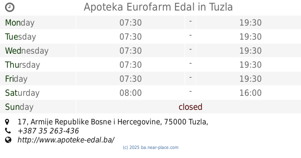
Apoteka Eurofarm Edal
Armije Republike Bosne i Hercegovine 17, Tuzla
Pharmacy
read more
38.763 km
Apoteka Adonis
Albina i Franje Herljevića 6, Tuzla
Pharmacy
read more
39.08 km
Apoteka Durić
Branilaca BiH 11, Tuzla
Pharmacy
read more
39.441 km
Bio Vita
B6, Tuzla
Pharmacy
read more
45.728 km
OS-PHARM
Dubrave Gornje
Pharmacy
read more
46.717 km
Eurofarm Edal
Kiseljak
Pharmacy
read more
48.8 km
Apoteka Đulović
Suha
Pharmacy
read more
49.101 km
Ibn Sina
Alije Izetbegovića 10, Živinice Grad
Pharmacy
read more
49.14 km
Mediflor
R455a, Bučik
Pharmacy
read more
50.053 km
MEDICA-Priluk
Priluk
Pharmacy
read more
📑
all categories
Accounting
Administrative area level 1
Administrative area level 2
Airport
Amusement park
Art gallery
Atm
Bakery
Bank
Bar
Beauty salon
Bicycle store
Book store
Bowling alley
Bus station
Cafe
Campground
Car dealer
Car rental
Car repair
Car wash
Casino
Cemetery
Church
City hall
Clothing store
Convenience store
Country
Courthouse
Dentist
Department store
Doctor
Electrician
Electronics store
Embassy
Establishment
Finance
Fire station
Florist
Food
Funeral home
Furniture store
Gas station
General contractor
Grocery or supermarket
Gym
Hair care
Hardware store
Health
Home goods store
Hospital
Insurance agency
Jewelry store
Laundry
Lawyer
Library
Light rail station
Liquor store
Local government office
Locality
Locksmith
Lodging
Meal delivery
Meal takeaway
Mosque
Movie rental
Movie theater
Moving company
Museum
Natural feature
Neighborhood
Night club
Park
Parking
Pet store
Pharmacy
Place of worship
Point of interest
Police
Post office
Premise
Real estate agency
Restaurant
Roofing contractor
Route
Rv park, camping
School
Shoe store
Shopping mall
Spa
Stadium
Storage
Store
Supermarket
Synagogue
Taxi stand
Train station
Transit station
Travel agency
University
Veterinary care
Zoo
administrative area level 3
sublocality level 1
↑