Pharmacy nearby Apteka Sarajevo
Bosnia and Herzegovina
Pharmacy nearby Apteka Sarajevo
Apteka Sarajevo
7, Zmaja od Bosne, 71000, Sarajevo, Sarajevska županija, BA Bosnia and Herzegovina
contacts phone
:
+387
Latitude:
43.8549022
, Longitude:
18.399988
larger map & directions
read more
nearest Pharmacy
372 m
Apoteka Galenpharm
Grbavička 2b, Sarajevo
Pharmacy
read more
429 m
Apoteka Medikaliz
15, Zagrebačka, Sarajevo
Pharmacy
read more
460 m
Remedia
Kranjčevićeva 43, Sarajevo
Pharmacy
read more
528 m
Apoteka Monis Sarajevo
Bulevar Franca Lehara 2 Sprat -1 Alta shopping centar, Sarajevo
Pharmacy
read more
624 m
Pharmacia
Vrbanja 1, Sarajevo
Pharmacy
read more
669 m
Zeni-Lijek
Derviša Numića, Sarajevo
Pharmacy
read more
705 m
Apoteke Sarajevo
Maršala Tita 1, Sarajevo
Pharmacy
read more
940 m
Apoteke Sarajevo
Vrazova 11, Sarajevo
Pharmacy
read more
967 m
Lupriv
Vrazova 22, Sarajevo
Pharmacy
read more
1.134 km
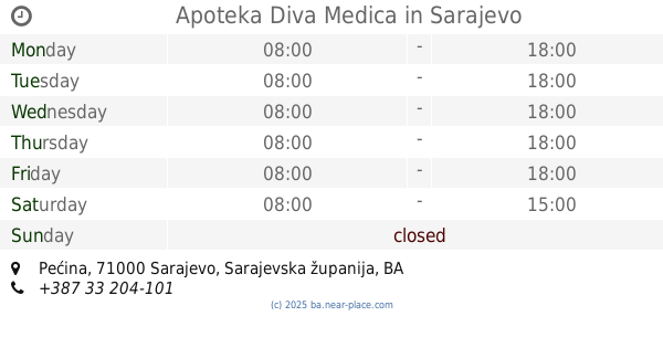
Apoteka Diva Medica
1,, Pećina, Sarajevo
Pharmacy
read more
1.138 km
Apoteke Sarajevo
Kolodvorska 41, Sarajevo
Pharmacy
read more
1.156 km
Apoteke Sarajevo
Reisa Džemaludina Čauševića 4, Sarajevo
Pharmacy
read more
1.16 km
Family pharm
Kemala Kapetanovića bb, Sarajevo
Pharmacy
read more
1.277 km
Apoteka PharmaSA
Trg Merhemica 5
Pharmacy
read more
1.312 km
Lupriv
Skenderija 5, Sarajevo
Pharmacy
read more
1.364 km
Altea
Koševo 32, Sarajevo
Pharmacy
read more
1.378 km
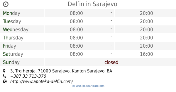
Delfin
Trg heroja 3, Sarajevo
Pharmacy
read more
1.428 km
Eurofarm Centar
Trg djece Sarajeva 1, Sarajevo
Pharmacy
read more
1.441 km
Family Plus
Kalesijska 1, Sarajevo
Pharmacy
read more
1.579 km
Vita
Maršala Tita 44, Sarajevo
Pharmacy
read more
1.658 km
Apoteke Sarajevo
Bolnička 9, Sarajevo
Pharmacy
read more
1.689 km
Dija-San
Envera Šehovića 54, Sarajevo
Pharmacy
read more
1.7 km
Apoteka Medisan
Jukićeva, Sarajevo
Pharmacy
read more
2.004 km
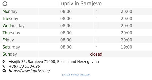
Lupriv
Višnjik 35, Sarajevo
Pharmacy
read more
2.142 km
Lupriv
Milana Preloga 2a, Sarajevo
Pharmacy
read more
📑
all categories
Accounting
Administrative area level 1
Administrative area level 2
Airport
Amusement park
Art gallery
Atm
Bakery
Bank
Bar
Beauty salon
Bicycle store
Book store
Bowling alley
Bus station
Cafe
Campground
Car dealer
Car rental
Car repair
Car wash
Casino
Cemetery
Church
City hall
Clothing store
Convenience store
Country
Courthouse
Dentist
Department store
Doctor
Electrician
Electronics store
Embassy
Establishment
Finance
Fire station
Florist
Food
Funeral home
Furniture store
Gas station
General contractor
Grocery or supermarket
Gym
Hair care
Hardware store
Health
Home goods store
Hospital
Insurance agency
Jewelry store
Laundry
Lawyer
Library
Light rail station
Liquor store
Local government office
Locality
Locksmith
Lodging
Meal delivery
Meal takeaway
Mosque
Movie rental
Movie theater
Moving company
Museum
Natural feature
Neighborhood
Night club
Park
Parking
Pet store
Pharmacy
Place of worship
Point of interest
Police
Post office
Premise
Real estate agency
Restaurant
Roofing contractor
Route
Rv park, camping
School
Shoe store
Shopping mall
Spa
Stadium
Storage
Store
Supermarket
Synagogue
Taxi stand
Train station
Transit station
Travel agency
University
Veterinary care
Zoo
administrative area level 3
sublocality level 1
↑