Lodging nearby Stanišići Ethno Village
Bosnia and Herzegovina
Lodging nearby Stanišići Ethno Village
Stanišići Ethno Village
32, Pavlovića put, 76300, Dvorovi, BA Bosnia and Herzegovina
contacts phone
:
+387 55 350-306
website:
www.etno-selo.com
Latitude:
44.784349
, Longitude:
19.2788446
larger map & directions
read more
nearest Lodging
53 m
Хотел ПИРГ
Bijeljina
Lodging
read more
119 m
Hotel Ras
Dvorovi
Lodging
read more
249 m
Motel Intergaj
Ive Andrića 41a, Dvorovi
Lodging
read more
2.746 km
Hotel Sveti Stefan
Dvorovi
Lodging
read more
3.016 km
Motel Neno
Majevičkih brigada, Dvorovi
Lodging
read more
3.598 km
Vikendica Drinsko Jutro
Pavlovica put bb, Popovi
Lodging
read more
4.503 km
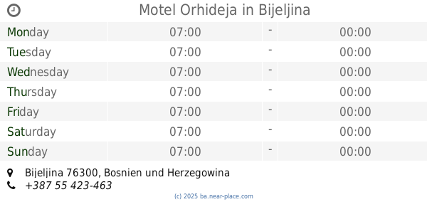
Motel Orhideja
Bijeljina
Lodging
read more
5.29 km
Apartman Mir
Kralja Milutina 10, Bijeljina
Lodging
read more
5.5 km
Apartman Astra 2
Njegoševa 28, Bijeljina
Lodging
read more
5.551 km
Apartment monte
Meše Selimovića 13, Bijeljina
Lodging
read more
5.663 km
Hotel Homa
Njegoševa 1, Bijeljina
Lodging
read more
5.699 km
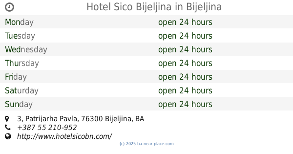
Hotel Sico Bijeljina
Patrijarha Pavla 3, Bijeljina
Lodging
read more
5.784 km
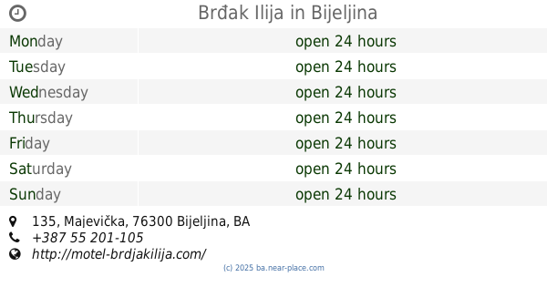
Brđak Ilija
Majevička 135, Bijeljina
Lodging
read more
5.815 km
Motel Azzurro
Majevička 170, Bijeljina
Lodging
read more
5.816 km
Apartman br 4
96 Majevička Apartman br.4
Lodging
read more
5.816 km
Apartman br.1
Majevička 96, Bijeljina
Lodging
read more
5.887 km
Hotel Azuro
Nikole Tesle, Bijeljina
Lodging
read more
5.967 km
Apartment 45
Gavrila Principa 3, Bijeljina
Lodging
read more
6.035 km
Apartments
18 Svetog Save Stefan Decanskog 161, Bijeljina
Lodging
read more
6.386 km
Apartman Gavric
81 Neznanih junaka Entrance V, 1st floor, Bijeljina
Lodging
read more
6.406 km
Motel Centar Bijeljina
Filipa Višnjića 83, Bijeljina
Lodging
read more
6.465 km
Apartman Cherry
28, Ive Andrića, Bijeljina
Lodging
read more
6.465 km
Apartment Snjezana
Ulica Dusana Baranjina 3, Bijeljina
Lodging
read more
6.466 km
Apartman Karma
Ive Andrića 28/29, Bijeljina
Lodging
read more
6.543 km
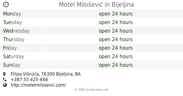
Motel Milošević
151, Filipa Višnjića
Lodging
read more
📑
all categories
Accounting
Administrative area level 1
Administrative area level 2
Airport
Amusement park
Art gallery
Atm
Bakery
Bank
Bar
Beauty salon
Bicycle store
Book store
Bowling alley
Bus station
Cafe
Campground
Car dealer
Car rental
Car repair
Car wash
Casino
Cemetery
Church
City hall
Clothing store
Convenience store
Country
Courthouse
Dentist
Department store
Doctor
Electrician
Electronics store
Embassy
Establishment
Finance
Fire station
Florist
Food
Funeral home
Furniture store
Gas station
General contractor
Grocery or supermarket
Gym
Hair care
Hardware store
Health
Home goods store
Hospital
Insurance agency
Jewelry store
Laundry
Lawyer
Library
Light rail station
Liquor store
Local government office
Locality
Locksmith
Lodging
Meal delivery
Meal takeaway
Mosque
Movie rental
Movie theater
Moving company
Museum
Natural feature
Neighborhood
Night club
Park
Parking
Pet store
Pharmacy
Place of worship
Point of interest
Police
Post office
Premise
Real estate agency
Restaurant
Roofing contractor
Route
Rv park, camping
School
Shoe store
Shopping mall
Spa
Stadium
Storage
Store
Supermarket
Synagogue
Taxi stand
Train station
Transit station
Travel agency
University
Veterinary care
Zoo
administrative area level 3
sublocality level 1
↑