Gas station nearby Euro Petrol Oil
Bosnia and Herzegovina
Gas station nearby Euro Petrol Oil
Euro Petrol Oil
Filipa Višnjića, 76300, Bijeljina, BA Bosnien und Herzegowina
contacts phone
:
+387 55 232-100
Latitude:
44.747803
, Longitude:
19.205311
larger map & directions
read more
nearest Gas station
1.196 km
Bijeljina put
Bijeljina
Gas station
read more
1.331 km
Gazprom
Stefana Dečanskog 119, Bijeljina
Gas station
read more
1.473 km
Despotović
Cara Uroša, Bijeljina
Gas station
read more
1.513 km
Nestro Petrol
Bijeljina
Gas station
read more
1.651 km
NIS Petrol
Sremska 2, Bijeljina
Gas station
read more
1.655 km
Intergaj
Bijeljina
Gas station
read more
2.145 km
Nestro
Hase
Gas station
read more
2.186 km
Нешковић доо
Živojina Mišića 9, Bijeljina
Gas station
read more
2.83 km
Nestro
Račanska 92, Bijeljina
Gas station
read more
3.383 km
Teco-promet
Ćipirovine
Gas station
read more
3.524 km
Vulkanizer
Ćipirovine
Gas station
read more
3.773 km
Dragstes
Velika Obarska
Gas station
read more
4.293 km
4. april-Trifković
Bijeljina
Gas station
read more
4.353 km
Petrić
Ljeljenča
Gas station
read more
4.824 km
Нешковић
Majevičkih brigada, Gojsovac
Gas station
read more
5.382 km
Benzinska Pumpa DRAGSTES
Velika Obarska
Gas station
read more
5.663 km
Петрол
#52, Majevičkih brigada 4, Dvorovi
Gas station
read more
7.487 km
Benzinska Pumpa Nešković
M14.1, Čađavica Donja
Gas station
read more
8.082 km
CSP
Bijeljinska, Janja
Gas station
read more
8.365 km
Neskovic Benzinska Pumpa
Janja
Gas station
read more
8.99 km
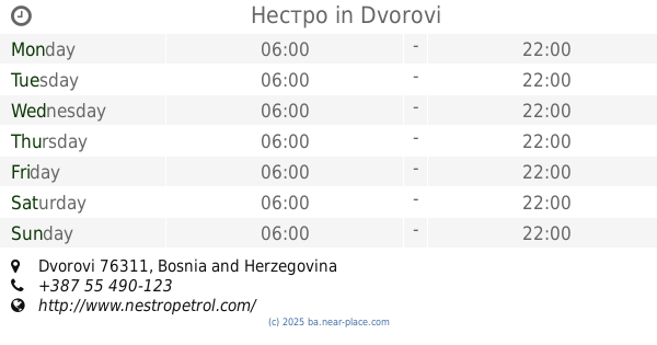
Нестро
Dvorovi
Gas station
read more
9.32 km
NIS Petrol
Janja
Gas station
read more
10.958 km
Nestro
Janja
Gas station
read more
33.489 km
Нешковић
Brčko
Gas station
read more
55.998 km
INA
D55, Županja
Gas station
read more
📑
all categories
Accounting
Administrative area level 1
Administrative area level 2
Airport
Amusement park
Art gallery
Atm
Bakery
Bank
Bar
Beauty salon
Bicycle store
Book store
Bowling alley
Bus station
Cafe
Campground
Car dealer
Car rental
Car repair
Car wash
Casino
Cemetery
Church
City hall
Clothing store
Convenience store
Country
Courthouse
Dentist
Department store
Doctor
Electrician
Electronics store
Embassy
Establishment
Finance
Fire station
Florist
Food
Funeral home
Furniture store
Gas station
General contractor
Grocery or supermarket
Gym
Hair care
Hardware store
Health
Home goods store
Hospital
Insurance agency
Jewelry store
Laundry
Lawyer
Library
Light rail station
Liquor store
Local government office
Locality
Locksmith
Lodging
Meal delivery
Meal takeaway
Mosque
Movie rental
Movie theater
Moving company
Museum
Natural feature
Neighborhood
Night club
Park
Parking
Pet store
Pharmacy
Place of worship
Point of interest
Police
Post office
Premise
Real estate agency
Restaurant
Roofing contractor
Route
Rv park, camping
School
Shoe store
Shopping mall
Spa
Stadium
Storage
Store
Supermarket
Synagogue
Taxi stand
Train station
Transit station
Travel agency
University
Veterinary care
Zoo
administrative area level 3
sublocality level 1
↑