Gas station nearby Binela komerc
Bosnia and Herzegovina
Gas station nearby Binela komerc
Binela komerc
Bosnia-Herzegovina
contacts phone
:
+387
Latitude:
44.1351531
, Longitude:
17.9110636
larger map & directions
read more
nearest Gas station
4.503 km
Brkić Petrol
M17
Gas station
read more
6.607 km
BP Orman
Zenica
Gas station
read more
6.831 km
Energopetrol
Sarajevska 61, Zenica
Gas station
read more
6.839 km
EP
Zenica
Gas station
read more
6.89 km
Tioil
Zenica
Gas station
read more
7.31 km
Hifa Petrol
Aleja šehida 20, Zenica
Gas station
read more
7.981 km
t-oil
Nikole Tesle 4, Zenica
Gas station
read more
8.016 km
Energopetrol
M17, Zenica
Gas station
read more
8.12 km
Energopetrol
Bulevar Kralja Tvrtka I, Zenica
Gas station
read more
8.231 km
Petrol
Zenica
Gas station
read more
8.289 km
Reunion
E73 bb, Zenica
Gas station
read more
9.427 km
Buba Benz
M5
Gas station
read more
10.153 km
Almy
Zenica
Gas station
read more
10.191 km
Bp ALMY Zenica 1
Vrandučka, Zenica
Gas station
read more
46.424 km
Petrol
Dobrinjska 1
Gas station
read more
46.991 km
Energopetrol
Kurta Schorka bb, Sarajevo
Gas station
read more
47.04 km
Bitumenka
Džemala Bijedića, Sarajevo
Gas station
read more
47.364 km
Proming
Džemala Bijedića 169a, Sarajevo
Gas station
read more
48.475 km
Tioil-TD
Želimira Vidovića - Kelija 121, Sarajevo
Gas station
read more
49.079 km
Selex
Milana Preloga 1A, Sarajevo
Gas station
read more
49.784 km
INA
M17, Sarajevo
Gas station
read more
50.326 km
M3
Aerodromska
Gas station
read more
51.957 km
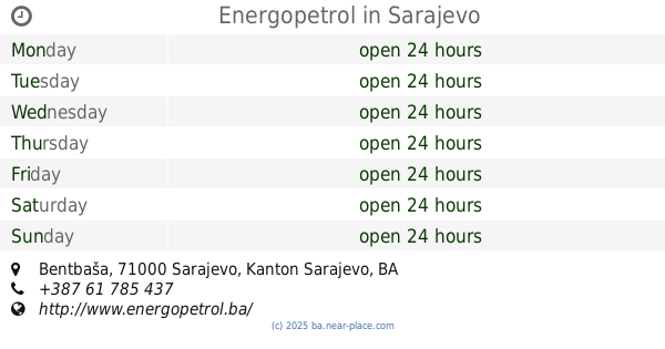
Energopetrol
Bentbaša, Sarajevo
Gas station
read more
59.568 km
Sultan benz
Poljice 75303
Gas station
read more
65.819 km
Hifa Petrol
Lukavačkih brigada, Lukavac
Gas station
read more
📑
all categories
Accounting
Administrative area level 1
Administrative area level 2
Airport
Amusement park
Art gallery
Atm
Bakery
Bank
Bar
Beauty salon
Bicycle store
Book store
Bowling alley
Bus station
Cafe
Campground
Car dealer
Car rental
Car repair
Car wash
Casino
Cemetery
Church
City hall
Clothing store
Convenience store
Country
Courthouse
Dentist
Department store
Doctor
Electrician
Electronics store
Embassy
Establishment
Finance
Fire station
Florist
Food
Funeral home
Furniture store
Gas station
General contractor
Grocery or supermarket
Gym
Hair care
Hardware store
Health
Home goods store
Hospital
Insurance agency
Jewelry store
Laundry
Lawyer
Library
Light rail station
Liquor store
Local government office
Locality
Locksmith
Lodging
Meal delivery
Meal takeaway
Mosque
Movie rental
Movie theater
Moving company
Museum
Natural feature
Neighborhood
Night club
Park
Parking
Pet store
Pharmacy
Place of worship
Point of interest
Police
Post office
Premise
Real estate agency
Restaurant
Roofing contractor
Route
Rv park, camping
School
Shoe store
Shopping mall
Spa
Stadium
Storage
Store
Supermarket
Synagogue
Taxi stand
Train station
Transit station
Travel agency
University
Veterinary care
Zoo
administrative area level 3
sublocality level 1
↑