Gas station nearby Benzinska Pumpa Petric
Bosnia and Herzegovina
Gas station nearby Benzinska Pumpa Petric
Benzinska Pumpa Petric
Čađavac, Bosnia-Herzegovina
contacts phone
:
+387
Latitude:
44.8410595
, Longitude:
18.8196173
larger map & directions
read more
nearest Gas station
1.146 km
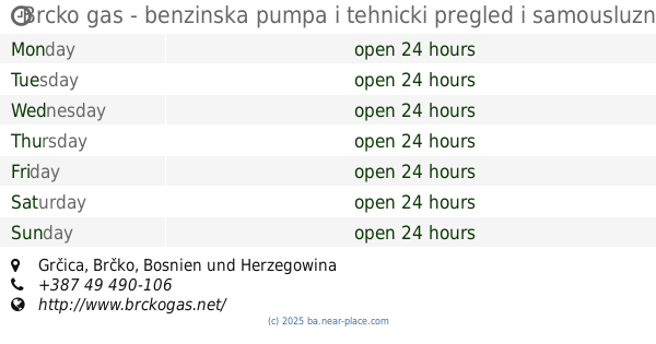
Brcko gas - benzinska pumpa i tehnicki pregled i samousluzna praonica vozila
Grčica
Gas station
read more
2.002 km
NGV-gas station
36 R458, Nikole Tesle, Brčko
Gas station
read more
2.253 km
MB-RADIĆ DOO
Bijeljinska 76, Brčko
Gas station
read more
2.369 km
Нешковић
Brčko
Gas station
read more
2.421 km
Energy Benz
Brčko
Gas station
read more
2.484 km
Benziska Pumpa
Petra Kočića 4, Brčko
Gas station
read more
2.542 km
Benzinska Pumpa Karamujić
76100, Petra Kočića 4, Brčko
Gas station
read more
3.002 km
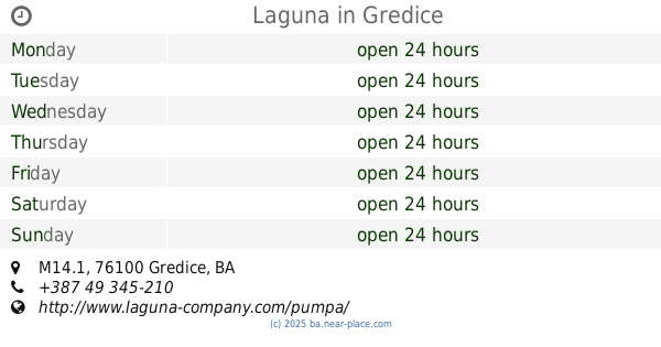
Laguna
M14.1, Gredice
Gas station
read more
4.167 km
Belamionix
Mostarska, Brčko
Gas station
read more
4.486 km
Energy Bentz
Mostarska 210, Brod
Gas station
read more
4.71 km
Gazprom
Banjalučka bb, Brčko
Gas station
read more
5.292 km
Agrotenika Petrol Bp Gredice
Brčko Distrikt
Gas station
read more
5.301 km
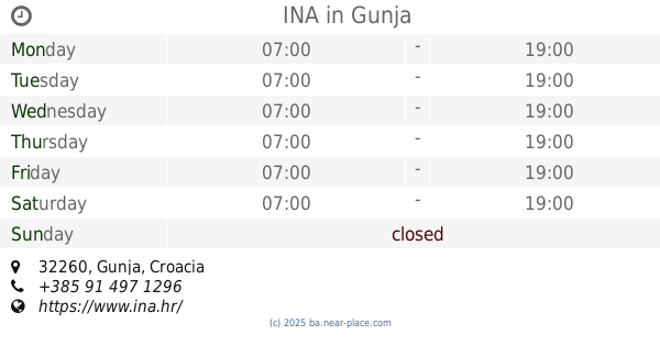
INA
Gunja
Gas station
read more
5.492 km
Antunovic
M14.1, Brčko
Gas station
read more
24.679 km
Benzinska Pumpa Nešković
M14.1, Čađavica Donja
Gas station
read more
26.952 km
Branikom
Donja Mahala
Gas station
read more
28.883 km
Benzinska Pumpa DRAGSTES
Velika Obarska
Gas station
read more
30.565 km
INA
D55, Županja
Gas station
read more
31.785 km
Despotović
Cara Uroša, Bijeljina
Gas station
read more
35.366 km
INA
Kulina bana 7, Tuzla
Gas station
read more
37.786 km
Neskovic Benzinska Pumpa
Janja
Gas station
read more
39.461 km
Belamionix
M1.8, Plane
Gas station
read more
47.416 km
Eneregopetrol
b.b., Magistralni put, Živinice Grad
Gas station
read more
47.422 km
Polo
M4, Memići
Gas station
read more
47.684 km
Oil
Živinice Grad
Gas station
read more
📑
all categories
Accounting
Administrative area level 1
Administrative area level 2
Airport
Amusement park
Art gallery
Atm
Bakery
Bank
Bar
Beauty salon
Bicycle store
Book store
Bowling alley
Bus station
Cafe
Campground
Car dealer
Car rental
Car repair
Car wash
Casino
Cemetery
Church
City hall
Clothing store
Convenience store
Country
Courthouse
Dentist
Department store
Doctor
Electrician
Electronics store
Embassy
Establishment
Finance
Fire station
Florist
Food
Funeral home
Furniture store
Gas station
General contractor
Grocery or supermarket
Gym
Hair care
Hardware store
Health
Home goods store
Hospital
Insurance agency
Jewelry store
Laundry
Lawyer
Library
Light rail station
Liquor store
Local government office
Locality
Locksmith
Lodging
Meal delivery
Meal takeaway
Mosque
Movie rental
Movie theater
Moving company
Museum
Natural feature
Neighborhood
Night club
Park
Parking
Pet store
Pharmacy
Place of worship
Point of interest
Police
Post office
Premise
Real estate agency
Restaurant
Roofing contractor
Route
Rv park, camping
School
Shoe store
Shopping mall
Spa
Stadium
Storage
Store
Supermarket
Synagogue
Taxi stand
Train station
Transit station
Travel agency
University
Veterinary care
Zoo
administrative area level 3
sublocality level 1
↑