Cafe nearby Čaršija
Bosnia and Herzegovina
Cafe nearby Čaršija
Čaršija
bb, Oslobođenja, 75270, Živinice Grad, Tuzlanski kanton, BA Bosnia and Herzegovina
contacts phone
:
+387 66 662 119
Latitude:
44.4501224
, Longitude:
18.6511776
larger map & directions
read more
nearest Cafe
7 m
Lotus
Oslobođenja bb, Živinice Grad
Cafe
read more
8 m
Max
Oslobođenja bb, Živinice Grad
Cafe
read more
13 m
M2
Oslobođenja bb, Živinice Grad
Cafe
read more
20 m
Mirakl
Oslobođenja bb, Živinice Grad
Cafe
read more
27 m
Capri
bb, Živinice Grad
Cafe
read more
56 m
Palma
Živinice Grad
Cafe
Point of interest
Food
Establishment
read more
91 m
Caffe City
Alije Izetbegovića 44, Živinice Grad
Cafe
read more
125 m
Erzurum
Bulevar Nesiba Malkića, Živinice Grad
Cafe
read more
9.518 km
Bazeni Erna
Priluk
Cafe
read more
9.557 km
Pink Panter
B2, Mehmedalije Maka Dizdara, Tuzla
Cafe
read more
9.562 km
San Marco Slasticarna Kafic
Stupine
Cafe
read more
9.904 km
Caffe Titanic
Tuzla
Cafe
read more
9.907 km
Caffe Autor
Klosterska 7, Tuzla
Cafe
read more
9.928 km
Kafe-bat Rijad
Jevrejska, Tuzla
Cafe
read more
9.971 km
Pause Caffe
Tuzla
Cafe
read more
9.983 km
Caffe BOSNA
Maršala Tita 199, Tuzla
Cafe
read more
9.999 km
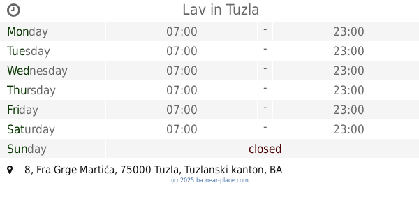
Lav
Fra Grge Martića 8, Tuzla
Cafe
read more
10.001 km
Laguna
TC Sjenjak prizemlje, Maršala Tita, Tuzla
Cafe
read more
10.04 km
Caffe Bar A.F.
Barok 10-12
Cafe
read more
10.048 km
Checkpoint
Zlatarska 3, Tuzla
Cafe
read more
10.083 km
Caffe Bar Stand By
Džafer mahala 42, Tuzla
Cafe
read more
10.255 km
Xelecto
Tuzla
Cafe
read more
12.554 km
Al Coffee
Bana Borića, Lukavac
Cafe
read more
12.674 km
Akva
Armije Republike Bosne i Hercegovine, Lukavac
Cafe
read more
13.185 km
Bambino
Petrak, Lukavac
Cafe
read more
📑
all categories
Accounting
Administrative area level 1
Administrative area level 2
Airport
Amusement park
Art gallery
Atm
Bakery
Bank
Bar
Beauty salon
Bicycle store
Book store
Bowling alley
Bus station
Cafe
Campground
Car dealer
Car rental
Car repair
Car wash
Casino
Cemetery
Church
City hall
Clothing store
Convenience store
Country
Courthouse
Dentist
Department store
Doctor
Electrician
Electronics store
Embassy
Establishment
Finance
Fire station
Florist
Food
Funeral home
Furniture store
Gas station
General contractor
Grocery or supermarket
Gym
Hair care
Hardware store
Health
Home goods store
Hospital
Insurance agency
Jewelry store
Laundry
Lawyer
Library
Light rail station
Liquor store
Local government office
Locality
Locksmith
Lodging
Meal delivery
Meal takeaway
Mosque
Movie rental
Movie theater
Moving company
Museum
Natural feature
Neighborhood
Night club
Park
Parking
Pet store
Pharmacy
Place of worship
Point of interest
Police
Post office
Premise
Real estate agency
Restaurant
Roofing contractor
Route
Rv park, camping
School
Shoe store
Shopping mall
Spa
Stadium
Storage
Store
Supermarket
Synagogue
Taxi stand
Train station
Transit station
Travel agency
University
Veterinary care
Zoo
administrative area level 3
sublocality level 1
↑