Cafe nearby Café Zaplet
Bosnia and Herzegovina
Cafe nearby Café Zaplet
Café Zaplet
Zagrebačka, 71000, Sarajevo, Kanton Sarajevo, BA Bosnia and Herzegovina
contacts phone
:
+387
Latitude:
43.8518745
, Longitude:
18.4024148
larger map & directions
read more
nearest Cafe
8 m
Che Guevara
Zagrebačka, Sarajevo
Cafe
read more
84 m
Nargila bar Argelini
Sarajevo
Cafe
read more
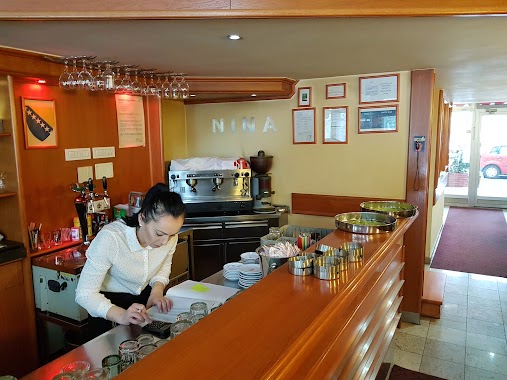
88 m
Nina
Grbavička 4, Sarajevo
Cafe
read more
145 m
College
Aleja Lipa, Sarajevo
Cafe
read more
172 m
Coffee Station
Zagrebačka 4a, Sarajevo
Cafe
read more
622 m
Crem
Vrbanja 1, Sarajevo
Cafe
read more
629 m
Boulevard
71000, Fra Anđela Zvizdovića 1, Sarajevo
Cafe
read more
631 m
Vatra
1, Vrbanja, Sarajevo
Cafe
read more
646 m
Buffet A3 La Perla
71000, Fra Anđela Zvizdovića 1, Sarajevo
Cafe
read more
683 m
Babaloo
Kranjčevićeva 19, Sarajevo
Cafe
read more
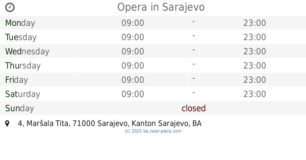
692 m
Opera
Maršala Tita 4, Sarajevo
Cafe
read more
698 m
Libertad
Kranjčevićeva 13, Sarajevo
Cafe
read more
699 m
San Remo
Kralja Tvrtka, Sarajevo
Cafe
read more
718 m
Mimoza
Kranjčevićeva 33, Sarajevo
Cafe
read more
751 m
'Ashar
Kranjčevićeva 43, Sarajevo
Cafe
read more
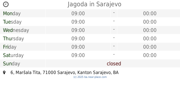
811 m
Jagoda
Maršala Tita 6, Sarajevo
Cafe
read more
816 m
Caffe Grad
Tešanjska 3, Sarajevo
Cafe
read more
861 m
Caffe Bar Nice
71000, Hamdije Čemerlića 17, Sarajevo
Cafe
read more
917 m
CoffeeVille
Pofalići, Sarajevo
Cafe
read more
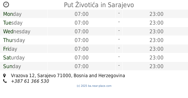
925 m
Put Životića
Vrazova 12, Sarajevo
Cafe
read more
940 m
Caffe Galerija MIRANDOL Skenderija
Skenderija, Sarajevo
Cafe
read more
984 m
Caffe 35 / Avaz Twist Tower
Tešanjska 24A, Avaz Twist Tower, Sarajevo
Cafe
read more
1.115 km
Old Trafford
Hamdije Čemerlića 31, Sarajevo
Cafe
read more
1.125 km
Euronet Y Caffe
Reisa Džemaludina Čauševića, Sarajevo
Cafe
read more
1.328 km
Medo Slasticarna
71000, Ruđera Boškovića 22, Sarajevo
Cafe
read more
📑
all categories
Accounting
Administrative area level 1
Administrative area level 2
Airport
Amusement park
Art gallery
Atm
Bakery
Bank
Bar
Beauty salon
Bicycle store
Book store
Bowling alley
Bus station
Cafe
Campground
Car dealer
Car rental
Car repair
Car wash
Casino
Cemetery
Church
City hall
Clothing store
Convenience store
Country
Courthouse
Dentist
Department store
Doctor
Electrician
Electronics store
Embassy
Establishment
Finance
Fire station
Florist
Food
Funeral home
Furniture store
Gas station
General contractor
Grocery or supermarket
Gym
Hair care
Hardware store
Health
Home goods store
Hospital
Insurance agency
Jewelry store
Laundry
Lawyer
Library
Light rail station
Liquor store
Local government office
Locality
Locksmith
Lodging
Meal delivery
Meal takeaway
Mosque
Movie rental
Movie theater
Moving company
Museum
Natural feature
Neighborhood
Night club
Park
Parking
Pet store
Pharmacy
Place of worship
Point of interest
Police
Post office
Premise
Real estate agency
Restaurant
Roofing contractor
Route
Rv park, camping
School
Shoe store
Shopping mall
Spa
Stadium
Storage
Store
Supermarket
Synagogue
Taxi stand
Train station
Transit station
Travel agency
University
Veterinary care
Zoo
administrative area level 3
sublocality level 1
↑