Bar nearby MK ISTOK Club House
Bosnia and Herzegovina
Bar nearby MK ISTOK Club House
MK ISTOK Club House
Banja Luka 78000, Bosnia and Herzegovina
contacts phone
:
+387 66 486 397
website:
www.mkistok.com
Latitude:
44.7745042
, Longitude:
17.1812232
larger map & directions
read more
nearest Bar
145 m
BikerBar KOŠNICA
Banja Luka
Bar
read more
223 m
CAFFE LIVE
Dragomira Drage Malića 2, Banja Luka
Bar
read more
227 m
Depopivo Pub
Sime Matavulja, Banja Luka
Bar
read more
252 m
Caffe bar PELARGOS
Maksima Gorkog 17, Banja
Bar
read more
272 m
Street Cafe Sime Matavulja Banjaluka
Sime Matavulja 18, Banja Luka
Bar
read more
276 m
~čova.buraz~
Krajiških brigada, Banja Luka
Bar
read more
328 m
Kružni tok
Krajiških brigada, Banja Luka
Bar
read more
697 m
Caffe Azzurro
78000, Marije Bursać 7, Banja Luka
Bar
read more
708 m
Kafe Bar KVART
Banja Luka
Bar
read more
719 m
Стакленац
Banja Luka
Bar
read more
724 m
Debela berta
Grčka, Banja Luka
Bar
read more
756 m
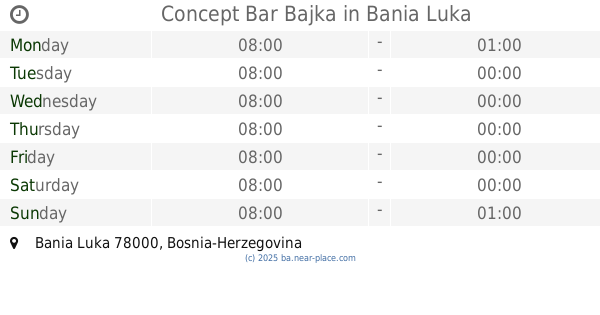
Concept Bar Bajka
Banja Luka
Bar
read more
757 m
koncept bar&restaurant BAJKA
52, Braće Mažar i majke Marije, Banja Luka
Bar
read more
762 m
alo alo
Banja Luka
Bar
read more
765 m
Pause
Vidovdanska, Banja Luka
Bar
read more
779 m
Kafe bar Senat
Vidovdanska 2, Banja Luka
Bar
read more
819 m
Smuggler
Kralja Petra I Karađorđevića 103, Banja Luka
Bar
read more
827 m
Cinema cafe
Banja Luka
Bar
read more
861 m
Fabrika Pub
Banja Luka
Bar
read more
866 m
Citadela
Kralja Alfonsa XIII 2, Banja Luka
Bar
read more
879 m
Tvornica Pub
Banja Luka
Bar
read more
913 m
Snek
Srpska 2, Banja Luka
Bar
read more
927 m
Mac Tire
Srpska 2-4, Banja Luka
Bar
read more
962 m
Cuba Libre
78000, Bana Milosavljevića, Banja Luka
Bar
read more
996 m
Kladionica Meridianbet
Bana Milosavljevića 34, Banja Luka
Bar
read more
📑
all categories
Accounting
Administrative area level 1
Administrative area level 2
Airport
Amusement park
Art gallery
Atm
Bakery
Bank
Bar
Beauty salon
Bicycle store
Book store
Bowling alley
Bus station
Cafe
Campground
Car dealer
Car rental
Car repair
Car wash
Casino
Cemetery
Church
City hall
Clothing store
Convenience store
Country
Courthouse
Dentist
Department store
Doctor
Electrician
Electronics store
Embassy
Establishment
Finance
Fire station
Florist
Food
Funeral home
Furniture store
Gas station
General contractor
Grocery or supermarket
Gym
Hair care
Hardware store
Health
Home goods store
Hospital
Insurance agency
Jewelry store
Laundry
Lawyer
Library
Light rail station
Liquor store
Local government office
Locality
Locksmith
Lodging
Meal delivery
Meal takeaway
Mosque
Movie rental
Movie theater
Moving company
Museum
Natural feature
Neighborhood
Night club
Park
Parking
Pet store
Pharmacy
Place of worship
Point of interest
Police
Post office
Premise
Real estate agency
Restaurant
Roofing contractor
Route
Rv park, camping
School
Shoe store
Shopping mall
Spa
Stadium
Storage
Store
Supermarket
Synagogue
Taxi stand
Train station
Transit station
Travel agency
University
Veterinary care
Zoo
administrative area level 3
sublocality level 1
↑