Bakery nearby Aspek
Bosnia and Herzegovina
Bakery nearby Aspek
Aspek
58, Maršala Tita, 71000, Sarajevo, Kanton Sarajevo, BA Bosnia-Herzegovina
contacts phone
:
+387 33 207-007
Latitude:
43.8587126
, Longitude:
18.4214826
larger map & directions
read more
nearest Bakery
96 m
Kaiser
Ferhadija 6, Sarajevo
Bakery
read more
112 m
Merak
Ferhadija 8, Sarajevo
Bakery
read more
137 m
BAKLAVA SARAJBOSNA
Gajev trg Sarajevo Bosna i Hercegovina
Bakery
read more
152 m
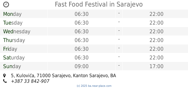
Fast Food Festival
Kulovića 5, Sarajevo
Bakery
read more
175 m
Olimpik
Gajev trg 2, Sarajevo
Bakery
read more
196 m
Maison Coco
Branilaca Sarajeva 10, Sarajevo
Bakery
read more
199 m
Pekara Markale
Mula Mustafe Bašeskije 8, Sarajevo
Bakery
read more
224 m
Farina
Maršala Tita 17, Sarajevo
Bakery
read more
437 m
Maison Coco
Sime Milutinovića Sarajlije, Sarajevo
Bakery
read more
490 m
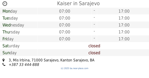
Kaiser
Mis Irbina 3, Sarajevo
Bakery
read more
554 m
Zec
Mis Irbina 6, Sarajevo
Bakery
read more
590 m
Aspek
Zelenih beretki 32, Sarajevo
Bakery
read more
621 m
Markale
71000, Koševo 11, Sarajevo
Bakery
read more
791 m
Sač
Bravadžiluk mali 2, Sarajevo
Bakery
read more
806 m
Slastičarna Sport
Bravadžiluk 7, Sarajevo
Bakery
read more
813 m
Buregdžinica Bosna
Bravadžiluk 11, Sarajevo
Bakery
read more
1.022 km
Kod Zuhdija
Hiseta 2, Sarajevo
Bakery
read more
1.118 km
Magros
Vrbanja 1, Sarajevo
Bakery
read more
1.13 km
Baklava Shop
Sarajevo City Centar (SCC) Vrbanja 1, Sarajevo
Bakery
read more
1.149 km
Juice&Smoothies
1, Vrbanja, Sarajevo
Bakery
read more
1.649 km
Pekara HAS
71000, Zagrebačka 13, Sarajevo
Bakery
read more
1.784 km
Vrt
Grbavička 6a, Sarajevo
Bakery
read more
1.841 km
Torte i to
Sarajevo
Bakery
read more
2.25 km
Pekara Grbavica
Grbavička 38, Sarajevo
Bakery
read more
2.276 km
Pekara Grbavica 2
Grbavička 52, Sarajevo
Bakery
read more
📑
all categories
Accounting
Administrative area level 1
Administrative area level 2
Airport
Amusement park
Art gallery
Atm
Bakery
Bank
Bar
Beauty salon
Bicycle store
Book store
Bowling alley
Bus station
Cafe
Campground
Car dealer
Car rental
Car repair
Car wash
Casino
Cemetery
Church
City hall
Clothing store
Convenience store
Country
Courthouse
Dentist
Department store
Doctor
Electrician
Electronics store
Embassy
Establishment
Finance
Fire station
Florist
Food
Funeral home
Furniture store
Gas station
General contractor
Grocery or supermarket
Gym
Hair care
Hardware store
Health
Home goods store
Hospital
Insurance agency
Jewelry store
Laundry
Lawyer
Library
Light rail station
Liquor store
Local government office
Locality
Locksmith
Lodging
Meal delivery
Meal takeaway
Mosque
Movie rental
Movie theater
Moving company
Museum
Natural feature
Neighborhood
Night club
Park
Parking
Pet store
Pharmacy
Place of worship
Point of interest
Police
Post office
Premise
Real estate agency
Restaurant
Roofing contractor
Route
Rv park, camping
School
Shoe store
Shopping mall
Spa
Stadium
Storage
Store
Supermarket
Synagogue
Taxi stand
Train station
Transit station
Travel agency
University
Veterinary care
Zoo
administrative area level 3
sublocality level 1
↑