Store nearby Plodine Vukovarska
Bosnia and Herzegovina
Store nearby Plodine Vukovarska
Plodine Vukovarska
221, Vinkovačka ulica, 32270, Županja, Općina Županja, HR Kroatien
contacts phone
:
+387 32 830-852
website:
plodine.hr
Latitude:
45.0937438
, Longitude:
18.701172
larger map & directions
read more
nearest Store
2.358 km
Maxi Konzum
Veliki kraj 77, Županja
Store
read more
6.222 km
Optika Isic Orašje
Treća ulica, Orašje
Store
read more
6.224 km
Optika Ena Orašje
Orašje
Store
read more
6.288 km
AVDAGA
53., Treća ulica, Orašje
Store
read more
6.427 km
Megakop Trgovina
II Ulica bb
Store
read more
7.526 km
dm
Prizemlje, Četrnaesta ulica 97, Orašje
Store
read more
7.553 km
Sport Vision
Prizemlje, Četrnaesta ulica 97, Orašje
Store
read more
9.017 km
Badžo
Poduzetnička zona, Orašje
Store
read more
24.987 km
GUTIĆ d.o.o.
Ulica Vladimira Nazora 346, Gunja
Store
read more
25.185 km
INTERSPORT BRČKO
Reisa Džemaludina Čauševića bb, Brčko
Store
read more
25.415 km
ZP Komerc
Brčko
Store
read more
25.433 km
dm
Trg mladih 4, Brčko
Store
read more
26.652 km
Mark Trade
Bijeljinska 20, Brčko
Store
read more
26.828 km
Megatrend - pozivnice za vjenčanje
Bijeljinska 48, Brčko Distrikt
Store
read more
28.269 km
Mitrašević
Slobodna carinska zona bb, Brčko
Store
read more
54.168 km
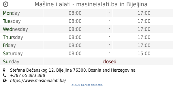
Mašine i alati - masineialati.ba
Stefana Dečanskog 12, Bijeljina
Store
read more
54.267 km
Vitamedic d.o.o.
Dvorovi
Store
read more
55.085 km
Ribarnica Darko-L
Filipa Višnjića 76, Bijeljina
Store
read more
55.115 km
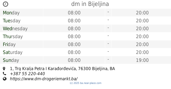
dm
Trg Kralja Petra I Karađorđevića 1, Bijeljina
Store
read more
55.415 km
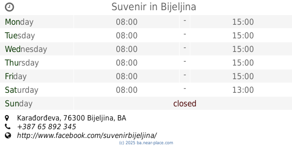
Suvenir
Karađorđeva
Store
read more
58.363 km
Izgradnja
M14.1, Patkovača
Store
read more
62.841 km
Agromix Mesnica
Doboj
Store
read more
62.887 km
TRGOVINAKUM
Doboj
Store
read more
63.301 km
Romansa
Doboj
Store
read more
64.401 km
Bingo
Karađođeva, Bijeljinska 201, Janja
Store
read more
📑
all categories
Accounting
Administrative area level 1
Administrative area level 2
Airport
Amusement park
Art gallery
Atm
Bakery
Bank
Bar
Beauty salon
Bicycle store
Book store
Bowling alley
Bus station
Cafe
Campground
Car dealer
Car rental
Car repair
Car wash
Casino
Cemetery
Church
City hall
Clothing store
Convenience store
Country
Courthouse
Dentist
Department store
Doctor
Electrician
Electronics store
Embassy
Establishment
Finance
Fire station
Florist
Food
Funeral home
Furniture store
Gas station
General contractor
Grocery or supermarket
Gym
Hair care
Hardware store
Health
Home goods store
Hospital
Insurance agency
Jewelry store
Laundry
Lawyer
Library
Light rail station
Liquor store
Local government office
Locality
Locksmith
Lodging
Meal delivery
Meal takeaway
Mosque
Movie rental
Movie theater
Moving company
Museum
Natural feature
Neighborhood
Night club
Park
Parking
Pet store
Pharmacy
Place of worship
Point of interest
Police
Post office
Premise
Real estate agency
Restaurant
Roofing contractor
Route
Rv park, camping
School
Shoe store
Shopping mall
Spa
Stadium
Storage
Store
Supermarket
Synagogue
Taxi stand
Train station
Transit station
Travel agency
University
Veterinary care
Zoo
administrative area level 3
sublocality level 1
↑