Gas station nearby Novalić oil
Bosnia and Herzegovina
Gas station nearby Novalić oil
Novalić oil
Polje Bijela, Bosnien und Herzegowina
contacts phone
:
+387
Latitude:
43.6394159
, Longitude:
17.9736492
larger map & directions
read more
nearest Gas station
252 m
TMK
Konjic
Gas station
read more
2.478 km
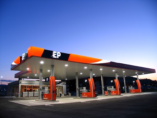
EP
Kolonija, Konjic
Gas station
read more
2.617 km
Gazprom
Kolonija, Konjic
Gas station
read more
2.783 km
EP
Mostarska, Konjic
Gas station
read more
4.167 km
Petrol
Podorašac, Živašnica
Gas station
read more
5.769 km
INA
M17, Sarajevo
Gas station
read more
34.863 km
Centrum
Dr Ante Starčevića bb, Mostar
Gas station
read more
35.221 km
M3
Aerodromska
Gas station
read more
35.487 km
Petrol
Dobrinjska 1
Gas station
read more
35.786 km
Braća Mujić
Džemala Bijedića 212, Sarajevo
Gas station
read more
36.082 km
Energopetrol
Kurta Schorka bb, Sarajevo
Gas station
read more
36.546 km
Petrol Dobrinja
Branislava Nušića, Sarajevo
Gas station
read more
36.98 km
Tioil-TD
Želimira Vidovića - Kelija 121, Sarajevo
Gas station
read more
37.504 km
Bitumenka
Džemala Bijedića, Sarajevo
Gas station
read more
37.842 km
Hifa Oil Nedzarići
Safeta Hadžića, Sarajevo
Gas station
read more
38.036 km
Energopetrol
Mostar
Gas station
read more
38.08 km
Proming
Džemala Bijedića 169a, Sarajevo
Gas station
read more
39.568 km
EP⛽
Bulevar Meše Selimovića, Sarajevo
Gas station
read more
39.768 km
Selex
Milana Preloga 1A, Sarajevo
Gas station
read more
41.365 km
Energopetrol
Hamdije Čemerlića, Sarajevo
Gas station
read more
42.045 km
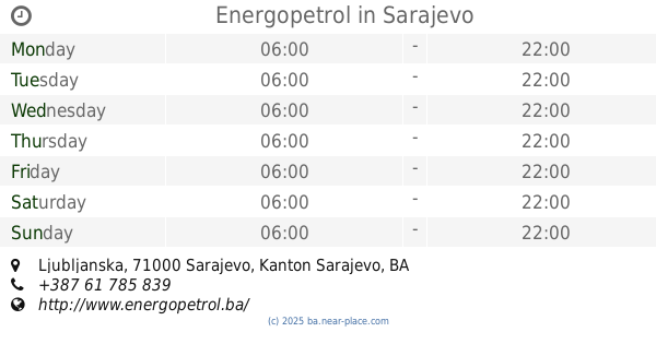
Energopetrol
Ljubljanska, Sarajevo
Gas station
read more
42.154 km
autoSpa
Ortiješ, Mostar
Gas station
read more
43.818 km
Gazprom
Asima Ferhatovića bb, Sarajevo
Gas station
read more
44.447 km
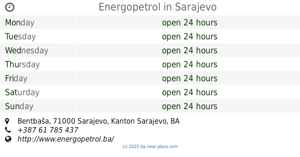
Energopetrol
Bentbaša, Sarajevo
Gas station
read more
54.066 km
Mališić Petrol
Tromeđa, Međugorje
Gas station
read more
📑
all categories
Accounting
Administrative area level 1
Administrative area level 2
Airport
Amusement park
Art gallery
Atm
Bakery
Bank
Bar
Beauty salon
Bicycle store
Book store
Bowling alley
Bus station
Cafe
Campground
Car dealer
Car rental
Car repair
Car wash
Casino
Cemetery
Church
City hall
Clothing store
Convenience store
Country
Courthouse
Dentist
Department store
Doctor
Electrician
Electronics store
Embassy
Establishment
Finance
Fire station
Florist
Food
Funeral home
Furniture store
Gas station
General contractor
Grocery or supermarket
Gym
Hair care
Hardware store
Health
Home goods store
Hospital
Insurance agency
Jewelry store
Laundry
Lawyer
Library
Light rail station
Liquor store
Local government office
Locality
Locksmith
Lodging
Meal delivery
Meal takeaway
Mosque
Movie rental
Movie theater
Moving company
Museum
Natural feature
Neighborhood
Night club
Park
Parking
Pet store
Pharmacy
Place of worship
Point of interest
Police
Post office
Premise
Real estate agency
Restaurant
Roofing contractor
Route
Rv park, camping
School
Shoe store
Shopping mall
Spa
Stadium
Storage
Store
Supermarket
Synagogue
Taxi stand
Train station
Transit station
Travel agency
University
Veterinary care
Zoo
administrative area level 3
sublocality level 1
↑